Animikie Group
On the map, the Animikie Group is the dark gray northeast-trending belt which ranges from south-central Minnesota, U.S., up to Thunder Bay, Ontario, Canada.
These sediments were deposited for two hundred million years and extend intermittently along roughly the same trend as the Great Lakes tectonic zone, from Minnesota into eastern Ontario, Canada, and through upper Wisconsin and Michigan.
The Sudbury Impact event occurred 1,850 million years ago; it is theorized that this caused the end of the banded-iron deposits.
The results of the impact affected concentrations of dissolved oxygen in the sea; the accumulation of banded-iron formations suddenly ended 1,850 million years ago.
[2] Deposition of sediments began after the Algoman orogeny and continued through the Great Lakes tectonic zone rupture from 2,200 to 1,850 million years ago.
[2] The extension was caused by the east-northeast–trending Great Lakes tectonic zone; it separates the Superior province from the Minnesota River Valley subprovince.
[2] The rocks of the Animikie Basin form a sequence up to 10 km (6.2 mi) thick and show a complete transition from a stable shelf environment to deep-water conditions.
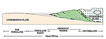
[4]: 6 The next tectonic event was the Great Lakes tectonic zone which began with compression caused by the collision of the Superior province and the Minnesota River Valley subprovince during the Algoman orogeny about 2,700 million years ago;[5] it continued as a pulling apart (extensional) rift from 2,450 to 2,100 million years ago,[6]: 145 followed by a second compression which deformed the rocks in the Lake Superior region during the Penokean orogeny which lasted from 1,900 to 1,850 million years ago.
[7] The first deposits occurred during the initial stages of extension of the Great Lakes tectonic zone in the continental crust.
[4]: 7 The Animikie strata on the Gunflint and Mesabi ranges were far enough away so they escaped this deformation and metamorphism; they contain some of the oldest unmetamorphosed sedimentary deposits in the world.
[4]: 7 A hotspot of magma from the Earth's mantle beneath present-day Lake Superior rose, causing the crust to dome and break apart.
[4]: 7 This zone of crustal thinning and fracturing is the Midcontinent Rift System; it extends in a boomerang shape for over 2,200 km (1,400 mi) from northeastern Kansas northward through Iowa, under the Twin Cities of Minnesota, beneath Lake Superior, and then south through the eastern Upper Peninsula of Michigan and beneath the central Lower Peninsula of Michigan.
[4]: 9 Subsidence continued for several million years after the lava flows had ceased; immense volumes of sediments – sand, gravel and mud – were eroded off the barren landscape into the still-sinking basin along the rift axis.
[9] These sediments were laid down for two hundred million years and extend intermittently along roughly the same trend as the Great Lakes tectonic zone, from Minnesota into eastern Canada, and through upper Wisconsin and Michigan.
[5]: 2 Microbial life played an important role in changing atmospheric conditions by releasing free oxygen as a waste product of photosynthesis.
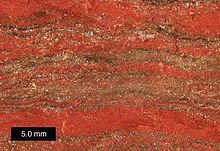
[5]: 2 Evidence for the change in oxygen levels is that the sediments of the earlier Archean are dark brown and black caused by unoxidized carbon, iron sulfide, and other elements and compounds.
[9] Banded-iron formations occur in several ranges around the margins of this basin, five of which contained sufficient concentrations of iron to be economically mined.
[2] These banded-iron formations have been one of the world's greatest sources of iron ore since mining began in the area during the late 19th century.
[11] Additional evidence indicates a 16 km (10 mi) diameter meteorite collided with Earth[12] in the current-day vicinity of Sudbury, Ontario, Canada.
[13] One use of the impact layer is as a precise timeline that ties together well-known stratigraphic sequences of the various geographically separated iron ranges.
The Gunflint and Mesabi ranges form a belt extending from the upper Mississippi River to the extreme northeast part of Minnesota and into Canada to Thunder Bay.
[5]: 4 These thick sedimentary layers contain millions of tons of iron and minor ores which have been mined in the Great Lakes region since before the turn of the 20th century.
[1] Pokegama Quartzite occupies the lowest level of the Mesabi Range sequence and is younger than 2,500 million years old.
[23]: 168 [26][27] The 1,850-million-year-old Virginia Formation is the sedimentary layer on top of the Biwabik Iron Range and forms the footwall of the 1,100-million-year-old Duluth Complex[28] in the Ely – Hoyt Lakes region.
[23]: 169 The Ely Greenstone is a belt consisting chiefly of metamorphosed volcanic rocks which have been deformed so that original bedding stands nearly vertical.
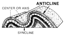
[31] In the Soudan area the Ely Greenstone has been tightly folded and slightly overturned southward into the Tower-Soudan anticline, and bedding is inclined 70-80° to the north.
[31] The volcanic rocks of the Ely Greenstone are divided into a lower and upper sequence; the upper and lower volcanic sequences are separated by the Soudan Iron Formation – a 50 to 3,000 m (160 to 9,840 ft) thick unit that is transitional with the Ely Greenstone – which consists chiefly of banded iron-formation.
[33] The rocks of the South and North ranges are separated by a major north-verging thrust fault, and both are overlain unconformably by the Emily District.
[1] The formation contains folded and metamorphosed greywacke, siltstone, mudstone and slate[1] which were originally deposited in the sea as horizontal beds of mud and sand; the Penokean orogeny subjected the rocks to intense compression from the south.
[19] The upper Baraga Group represents deeper marine basins resulting from increased subsidence and continued collision.