Antofagasta
Antofagasta (Spanish pronunciation: [antofaˈɣasta] ⓘ) is a port city in northern Chile, about 1,100 kilometres (700 mi) north of Santiago.
On 18 September 1866, José Santos Ossa and Francisco Puelma achieved the award of the concession of nitrate lands, following a request taken to the Bolivian government.
[citation needed] The exploring of the Chilean miners found rich deposits of saltpeter (nitratine) in the field of Salar del Carmen, to the east of the present Antofagasta.
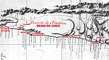
Faced with a looming conflict with Chile, Bolivia decided to claim support under the agreement signed with Peru, and the treaty became effective with the Chilean occupation of Antofagasta, on 14 February 1879.
[citation needed] At the breaking of the boundary treaty by Bolivia, and the cancellation of the contract of the CSFA, Chile seized Antofagasta, then in Bolivian territory, whose sovereignty had been ratified before 1866.
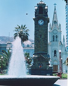
In 1912, the British community (La Colonia Britanica) erected a clock tower, replicating Big Ben, in Plaza Colón to celebrate the republic's centenary.
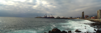
[citation needed] The urban area of Antofagasta begins abruptly, breaking the monotony of the desert and is located in the coastal plains, south of Mejillones Peninsula and north of "Cerro Coloso".
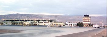
The Tropic of Capricorn passes in the north of the city, outside the urban area, which is located the Cerro Moreno International Airport.
[15] The town of Antofagasta has a cold desert climate (Köppen BWk) with abundant sunshine and strong maritime influence.
The marked aridity and water scarcity are regulated by the Humboldt Current, in addition to the high humidity and morning fog known as "Camanchaca".
[20] However, the sporadic occurrence of heavy rainfall, together with the geomorphologic situation of the city, make it susceptible to be affected by mud flows and landslides.
As a commune, Antofagasta is a third-level administrative division of Chile administered by a municipal council, headed by an alcalde who is directly elected every four years.
[28] The second industrial area is located in the north of the city, where they have installed multiple operating centers of different companies, mainly along the "Pedro Aguirre Cerda Avenue."
[29][30] Trade is concentrated mainly in the center of Antofagasta, around the Plaza Colón, where within the last 2 decades several national retail chains were in place.
Moreover, in different parts of the city large supermarket chains like "Líder", "Tottus", "Unimarc", "Santa Isabel" and "Jumbo" are set up.
[citation needed] Events are held annually with the assistance of several mining countries of the world, and one of the most important is Exponor organized by the Asociación de Industriales Antofagasta, guild formed by the major copper producers in the region.
[32] According to the 2002 census of the National Statistics Institute, Antofagasta had 296,905 inhabitants spread over an area of 30,718 km2 (11,860 sq mi), of which 143,685 are women and 153,220 were men.
In addition, the city is connected to the north of the country by Route 1-CH, a way that also allows access to Andrés Sabella Gálvez International Airport and the natural monument La Portada.
Vehicular traffic is concentrated around the main avenues of the city due to the long and narrow shape of the urban area.
The city has a port complex of seven docks, inaugurated by President Carlos Ibáñez del Campo on 14 February 1943[citation needed] under the name of Puerto de Antofagasta, which consists of two terminals.
2, composed of docks 4, 5, 6 and 7, monooperario type, which is managed and operated by the company "Antofagasta Terminal Internacional" (ATI) since 1 March 2003.
The higher transportation consists of thirteen lines of minibuses, which correspond to buses with a capacity of fewer than thirty people.
[35] The route of these buses finish in the Caleta Coloso (south end of the city) during the year, and during the summer come as far as Balneario Juan Lopez, which is out of town.
The lower transport consists of taxis lines, corresponding to a black sedans that make their way through the urban area through fixed routes.
[citation needed] It provides a variety of transportation services - most notably, the transport of mining products and consumables such as copper cathodes and sulfuric acid - via a 900 kilometers (560 mi) long rail network that is connected to the Ferrocarril Andino de Bolivia, Ferronor (Chile), and Ferrocarril Belgrano in Argentina (Salta–Antofagasta railway).
The project aims to decongest vehicle traffic by linking the north and south of the city with a direct train line.
The transaction is approved by the Executive held on 27 November 1873 with the manager of the CSFA provided to secure, at a minimum, a tax of ten cents per quintal of nitrate exported.