Calama, Chile
There are a variety of hypotheses about the origin of the name "Calama," but the two main accounts suggest that it comes from the Kunza language, spoken in the past by the Lickan-antay, an ethnic group that resides in the El Loa Province.
Hector Pumarino Soto suggests that "Calama" stems from the Kunza word "Ckara-ama," which means "town in the middle of the water".
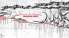
At the intersection of the Camino del Inca (the longitudinal one) and the routes that crossed the coast of the Altiplano, Calama became the main shelter of the Despoblado of Atacama.
In fact, when Diego de Almagro, returning from Cusco, passed by the Calama shelter, the natives gave him copper horseshoes, which were made using a mysterious Incan technique used by towns conquered by the Incas.
These changes influenced the control of trade routes that crossed the desert and communication to the port of Cobija with the deposits of Potosí silver and the cattle farms of Salta and Tucumán.
The greater dispute concentrated in the central prairie and in the coast, where they began to discover rich silver deposits, saltpeter, and guano.
The environment was made tense when Chilean troops, under the command of colonel Emilio Sotomayor Baeza, invaded the port of Antofagasta on the morning of February 14, 1879.
In 1888, under the government of José Manuel Balmaceda, Calama returned as an administrative center of 3° order, inaugurated as the municipality on 13 October.
According to the 2002 census of the National Statistics Institute, Calama has an area of 15,596.9 km (9,691 mi) and has 138,402 inhabitants (70,832 men and 67,570 women).
[2] As a commune, Calama is a third-level administrative division of Chile administered by a municipal council, headed by an alcalde who is directly elected every four years.