Appalachian Trail by state
An 8.8-mile (14.2 km) approach trail (not part of the AT) begins at the Amicalola Falls State Park visitor center.
The section that runs just below the summit of Kuwohi (formerly Clingmans Dome) in Great Smoky Mountains National Park is the highest point on the trail at 6,625 feet (2,019 m).
In the western Smokies, the trail traverses a young forest that replaced what was once a large highland pasture, most noticeable in areas such as Spence Field, Thunderhead Mountain, and Silers Bald.
Atop Roan High Knob, the A.T. again eclipses 6,000 feet (approximately 6,280 ft or 1,910 m), and passes the highest shelter along the entire trail.
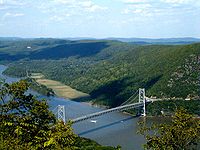
[7] Substantial portions of the trail closely parallel Skyline Drive in Shenandoah National Park and, further south, the Blue Ridge Parkway.
The three iconic peaks that make up the Triple Crown are McAfee Knob, Dragon's Tooth, and Tinker Cliffs.
[10] Three weeks of rain uprooted thousands of trees in what Mike Dawson of the Appalachian Trail Conference called "the worst break in the continuous footpath since it was declared open from Maine to Georgia in August 1937.
The trail also goes through Pen Mar Park, which is just north of High Rock, which offers views and is a hang-gliding site.
On March 15, 2015, a hiker was killed near the Ed Garvey shelter in the southern part of the state's portion of the trail when a large tree fell on him.
The two parts are separated by the broad Cumberland Valley, where the trail has a change of scenery, crossing many farms and large highways.
In the northern half of the state, the AT climbs back up into the mountains and passes through St. Anthony's Wilderness, which is the second largest roadless area in Pennsylvania and home to several coal mining ghost towns, such as Yellow Springs and Rausch Gap.
With the description of "where boots go to die",[18] Pennsylvania is infamous among thru-hikers for having more long stretches of rocky trail than any other state, although many feel the rocks are overrated.[who?]
The trail enters New Jersey from the south on a pedestrian walkway along the Interstate 80 Delaware Water Gap Toll Bridge over the Delaware River, ascends from the Delaware Water Gap to the top of Kittatinny Ridge in Worthington State Forest, passes Sunfish Pond, continues north through the Delaware Water Gap National Recreation Area and Stokes State Forest, and eventually reaches High Point State Park, highest peak in New Jersey (a side trail is required to reach the actual peak).
It then turns in a southeastern direction along the New York-New Jersey border for about 30 miles (48 km), passing over long sections of boardwalk bridges over marshy land, then entering Wawayanda State Park and then the Abram S. Hewitt State Forest just before entering New York near Greenwood Lake.
In Harriman State Park, the trail passes through the famous Lemon Squeezer, a narrow crack between huge boulders.
It then passes through Fahnestock State Park and continues northeast and crosses the Metro-North Railroad's Harlem Line at Pawling, which is also the only train station along the length of the trail.
[22] That portion of the trail is composed of 800 steps made of 1,000-pound (450 kg) slabs of granite followed by over a mile of walkway supported by stone crib walls with boulders called gargoyles lining the path.
The trail climbs ridges above the town of Kent, and then works its way past the Housatonic River to Falls Village, where it regains the heights.
After the town of Salisbury, the trail ascends into the Taconic Range, crossing, in order: Lions Head, Riga Ridge, and Bear Mountain, after which the Massachusetts line is achieved at Sage's Ravine.
The trail passes within one mile (1.6 km) of the business district of Kent, a resupply point for long-distance hikers.
The A.T. climbs the highest peak in the southern Taconic Mountains, Mount Everett (2,602 ft or 793 m), then descends to the Housatonic River Valley and skirts the towns of Egremont, Sheffield, and of Great Barrington.
It then quickly descends to the valley of the Hoosic River within 2 miles (3 km) of North Adams and Williamstown, before ascending again to the Vermont state line.
The trail traverses the Glastenbury, Lye Brook, and Peru Peak Wilderness areas of the Green Mountain National Forest.
[26] The NPS challenged Killington and Pico ski resorts in Vermont over development of private land that crossed the AT.
It comes close to the summits of 9 other of the 48 four-thousand footers: Liberty, Garfield (60 yards away over ledges), Galehead, Zealand, Eisenhower, Monroe, Jefferson, Adams, and Moriah.
[31] The western section includes a mile-long (1.6 km) stretch of boulders at Mahoosuc Notch, often called the trail's hardest mile.
The central Maine section crosses the Kennebec River at a point where it is 200 feet (61 m) wide, the widest unbridged stream along the trail.
This section heads east-northeast from the town of Monson and ends outside Baxter State Park just south of Abol Bridge.
Baxter State Park closes the summer rules overnight camping season from October 15 to May 15 each year.
Starting in the 1980s there have been frequent discussions about the ski area's development on or near the AT, most recently over the construction of a solar farm and lodge three miles from the trail, which was approved in early 2021.