North Country Trail by state
Along its total distance, the NCT traverses more than 150 public land units, including parks, forests, scenic attractions, wildlife refuges, game areas, and historic sites.
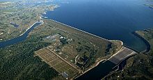
Starting in Burleigh County it walks alongside most of the 73-mile-long (117 km) McClusky Canal, followed by a trail through Lone Tree Wildlife Management Area (North Dakota's largest).
The trail passes through the small village of Kathryn in Barnes County then turns south again and walks through Fort Ransom State Park, followed by the wildlife management area and town of the same name.
Now trending to the southeast, the NCT walks through Lisbon in Ransom County, after which it turns primarily to the east then northeast and spends about 33 miles (53 km) on footpaths and old roads in Sheyenne National Grassland.
The trail then makes a U-turn to the north and walks through the east side of Fergus Falls before returning to rural areas of Otter Tail County.
Heading to the north, the NCT spends about six miles in Maplewood State Park, then turns primarily northeast to visit many small lakes in this region of Minnesota.
[8] Continuing to the north through lake country, the NCT spends more than 160 miles (257 km) in a succession of mostly contiguous public lands, starting with Hubbel Pond Wildlife Management Area in Becker County.
Starting in the eastern reaches of Chippewa National Forest, the NCT walks along Minnesota State Highway 6 (MN 6) for several miles, then turns east on rural roads to the town of Cohasset.
The NCT uses rural roads around the west and north sides of Hibbing, utilizing several public parks, followed by a brief encounter with Chisholm and a walk through Buhl in St. Louis County.
Still roughly following US 169 to the east, the NCT uses a suburban street to pass under the US 53 expressway and then enters extensive residential and commercial districts in Virginia, with a walk through parklands along that city's lakes.
The NCT then passes through Vermilion Trail Park and walks for a short distance alongside Embarrass Lake, and then loosely follows the river of the same name to the northeast.
The NCT briefly encounters the shore of Lake Superior at Saxon Harbor County Park, then joins a rural road to a remote crossing of the Montreal River at the Michigan state line.
The trail briefly encounters Lake Superior at Black River Harbor Recreation Area, then turns back to the south then east through more national forest lands.
After turning back to the north and walking along the Presque Isle River, the trail encounters Lake Superior again near Manabeznho Falls and then continues relatively parallel to the lakeshore, passing through several campgrounds.
After leaving the city, the trail heads east through rural areas within sight of the lakeshore and visits some more discontiguous segments of Gwinn Forest Management Unit.
[17] After the bridge, the NCT walks through Mackinaw City and continues southwest through rural areas in Gaylord Forest Management Unit and Wilderness State Park, including a brief encounter with Lake Michigan.
The trail reaches Lake Michigan again at Petosky State Park and then walks for several miles through the city of Petoskey, including urban parklands along the Bear River.
The NCT then heads southeast through additional remote segments of Gaylord Forest Management Unit, interspersed with occasional rural road walking.
In Wexford County, the trail passes into the Cadillac Forest Management Unit and walks for several miles alongside three stretches of the Manistee River, with another crossing of US 131.
The trail walks briefly through Augusta and a small corner of Fort Custer State Recreation Area, and then heads east through the city of Battle Creek.
Now trending east again, the NCT next passes through Lost Nation State Game Area, then turns south to the Ohio border near the town of Waldron.
[25] The combined trail turns southwest and follows an old canal towpath and rural roads along the river for a considerable distance, passing through several local parks and preserves.
After a few miles on rural roads, the trail heads through undeveloped lands alongside Loramie Creek, and passes through the villages of Newport, Dawson, and Newbern in Shelby County.
The trail then traverses local parklands for a considerable distance in Troy, Tipp City, and Vandalia (where it passes under I-70), still in the valley of the Great Miami River.
In Warren County, the trail passes through the village of Corwin and Caesar Creek Gorge State Nature Preserve, enters the northeastern suburbs of the Cincinnati metro area, and then continues to an imposing underpass at I-71 near Fort Ancient.
To the north, the trail briefly walks alongside Leesville Lake in Carroll County then roughly follows the floodplain of Conolton Creek via rural roads to the northwest.
The trail proceeds through undeveloped forest lands and walks through the small town of Darlington, then continues on a combination of footpaths and rural roads to the north.
The NCT then enters Moraine State Park, passes under US 422, and then joins the preexisting Glacier Ridge Trail for about the next 15 miles (24 km), including a crossing of PA 528.
[30] After walking through the grounds of Jennings Environmental Education Center, the NCT continues to the northeast on rural roads, followed by long stretches of footpath hiking through two segments of State Game Lands 95, where Slippery Rock Creek is encountered again.
[32] Near the New York Border, the NCT enters the northern segment of Allegheny National Recreation Area and uses a portion of the Tracy Ridge Hiking Trail System to walk alongside the reservoir for an extended distance.