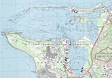
Apra Harbor
The southern boundary of Sasa Bay is formed by Polaris Point, a geographically separate part of Naval Base Guam that is the homeport of Submarine Squadron 15.
The Orote Peninsula holds the main part of Naval Base Guam and is approximately four miles to its tip at Point Udall.
[3] During Spanish rule, the name of Saint Louis IX was added and the harbor was referred to as the port of San Luis de Apra.
However, it was not a favored anchorage during the Spanish–Chamorro Wars of the late seventeenth century and resulting the early Spanish period, mainly because of the many reefs and coral heads.
[8] In 1734, Governor Francisco de Cárdenas Pacheco opened up new anchorages in Apra Harbor, and built three cannon batteries or forts to protect them.
[3] William Haswell, an officer on the first documented American visit to Guam in January 1802, wrote a description of Apra Harbor:[11] On the S.W.
In the 1840s, up to 60 whaling ships stopped in Apra Harbor every year, turning Sumay into the commercial and financial center of the island.
[3] American captain Henry Glass had received intelligence that Spanish men-of-war were anchored at Guam and that the harbor itself had formidable defenses.
However, when Glass arrived in Apra Harbor on June 20, 1898 to claim the island on behalf of the United States, he encountered no resistance.
The new American Naval government also began to develop the harbor, though launch boats were still required to navigate the coral reefs to land at Piti and Sumay.
[13] On March 17, 1921, U.S. suspicions of Japanese intentions for its South Seas Mandate led it to create a U.S. Marine Squadron floatplane base at Sumay.
[17] In 1935, Pan American Airways established rights to use the former Marine Aviation facility and made Sumay a base for its China Clipper.
With tensions rising after the 1931 Japanese invasion of Manchuria starting the Second Sino-Japanese War, Rear Admiral Arthur Japy Hepburn was appointed on June 7, 1938 to chair a board to provide recommendations on the American response.
In Apra Harbor, the storm damaged the Navy Yard at Piti and the Marine barracks and Pan American Airways facilities at Sumay.
[14]: 344 A 1946 Navy report notes, "practically all the [Hepburn] board's recommendations, except those relating to Guam, were carried out and contributed materially to our position when war actually developed.
[citation needed] Orote Peninsula was the center of Japanese resistance during the U.S. liberation of Guam in 1944 and the area around the harbor saw intense fighting.
Full scale development began with arrival of the NCB 301 headquarters and barracks ship City of Dalhart on 11 August 1944.
The northern arm of Apra Harbor, from the main island through Cabras to the tip of the breakwater at Spanish Rocks measured 17,000 feet (5,200 m).
[14]: 350 The residents of Sumay were not allowed to return and rebuild their homes, and the U.S. military relocated them to a refugee camp in the nearby inland hills in 1946.
[1] On August 12, 1974, the tug towing RMS Caribia, a decommissioned passenger ship, to Taiwan sailed into the tropical storm that later became Typhoon Mary and attempted to reach safety at Apra Harbor.
[26] In 1997, Guam designated Sasa Bay, which is located in the east of the Harbor as a marine preserve in order to protect declining fish populations.
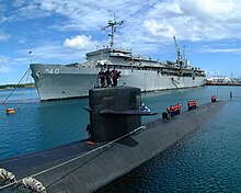
The largest tenant unit at Naval Base Guam is Submarine Squadron 15, which is supported by ship tender USS Frank Cable.
[citation needed] Coast Guard Station Apra Harbor is also located on Naval Base Guam property and has an area of responsibility including the Mariana Islands, Palau and the Federated States of Micronesia; it has three Sentinel-class cutters: Frederick Hatch, Myrtle Hazard, and Oliver Henry; and the Seagoing Buoy Tender USCGC Sequoia.
[29] Kilo Wharf, located on the Orote Peninsula near the mouth of the harbor, is the only U.S. deep water ammunition port in the Western Pacific and also allows emergency berthing by visiting aircraft carriers,[30][31] such as during the 2020 COVID-19 outbreak aboard USS Theodore Roosevelt.
[43][44] The Sasa Bay Marine Preserve, comprising waters and lands between Drydock Island and Polaris Point, is a recreational and ecological protected area with regulated fishing.
[45] The Preserve contains a mangrove swamp, is a foraging area for Hawksbill sea turtle and is habitat for several oyster and clam species.
[46] Operations in Outer Apra Harbor are under the jurisdiction of The Port Authority of Guam and the United States Coast Guard.