After its launch aboard a Delta II from Vandenberg Air Force Base in California, SAC-D was carried into a 657 km (408 mi) Sun-synchronous orbit to begin its 3-year mission.
[2] On June 7, 2015, the SAC-D satellite carrying Aquarius suffered a power supply failure, ending the mission.
The Aquarius sensors are flown on the (now inoperative) Satélite de Applicaciones Científicas (SAC)-D spacecraft 657 kilometers (408 miles) above earth in a sun-synchronous, polar orbit that repeats itself once a week.
Aquarius' three radiometers have antenna reflectors 2.5 meters (8.2 feet) in diameter that are able to scan a 390 kilometer (242 mile) wide swath of the ocean's surface collectively.
[7] Raw data records from the Aquarius instrument was transmitted from CONAE to the ground station at NASA's Goddard Space Flight Center (GSFC) in Greenbelt, MD.
Aquarius' ability to consistently map the oceans enables scientists to create more advanced computer models to study sea surface salinity and potentially forecast future climate conditions.
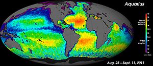
Ocean Salinity Map developed with Aquarius' first light data
The NASA Aquarius instrument aboard Argentina's SAC-D satellite is designed to measure global sea surface salinity. This movie shows salinity patterns as measured by Aquarius from December 2011 through December 2012. Red colors represent areas of high salinity, while blue shades represent areas of low salinity. It is important to understand salinity, the amount of dissolved salts in water, because it will lead us to better understanding of the water cycle and can lead to improved climate models. High concentrations (over 37 practical salinity units) are usually in the center of the ocean basins away from the mouths of rivers, which input fresh water. High concentrations are also in sub-tropical regions due to high rates of evaporation (clear skies, little rain, and prevailing winds) and in landlocked seas in arid regions. At high latitudes, salinity is low. This can be attributed to lower evaporation rates and the melting of ice that dilutes seawater. To sum up, salinity is low where precipitation is greater than evaporation, mainly in coastal or equatorial regions. Credit: NASA/GSFC/JPL-Caltech