Artificialization
Artificialization is often summed up as the disappearance of natural spaces under concrete or bitumen, during the construction of buildings (apartment blocks, hotels, houses, shops, industries, parking lots) or transport networks.
While soil sealing is a huge part of land artificialisation, more generally, it takes place when natural environments are heavily transformed by man.
On average, 165 ha, or 1,650,000 m² of natural environments and farmland, are destroyed every day in France and replaced by roads, housing, and business parks,[2] as part of the urban sprawl phenomenon.
[1] One of the aims of the French Green and Blue Network (TVB or Schéma régional de cohérence écologique) is to limit this phenomenon and mitigate its consequences.
Areas affected by artificialization include: As far as geomorphological and subsoil effects are concerned, the artificialization of the environment began modestly in prehistoric times: clearing by fire, occupation, and development of caves, increasingly sedentary and built-up human habitat, digging of shafts in the subsoil for flint mining, then seed silos and shafts or galleries for the exploitation of metal ore seams, from the Bronze Age onwards.
At the same time, the construction of fords, then bridges, dykes, mills, and systems for impounding and regulating watercourses and for drainage spread, culminating in major episodes of polderization, etc.
This accelerated the anthropization of the landscape and subsoil, colonized by millions of kilometers of cables, pipes, and sewers, including in the colonies of wealthy countries on every continent.
[7] Some areas are particularly hard hit: a large part of the coastline and estuaries of many countries has been artificialized by the construction of seaside resorts, coastal road networks, and port facilities.
[3] Artificialization is moving towards developing countries, with peri-urbanization particularly marked in the vicinity of megacities and urban metropolises (in France, for example, the Île-de-France and Toulouse).
In fifty years, seven million hectares of land have been buried for housing (40%), the economy (30%: businesses, warehouses, shops), and transport infrastructure (30%).
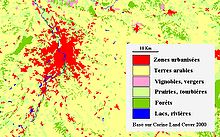
A study by the Cerema (the French Environment and Spatial Planning Agency) reveals a high level of artificialisation on the coast and around medium-sized towns and cities.
[13][14] Despite this upturn, the Senate majority is calling for a moratorium on the application of the 2021 Climate and Resilience Act, tabling bills to extend deadlines and pointing to the lack of financial resources dedicated to achieving the goal of zero net artificialization.
In June 2022, the Association des maires de France (AMF) lodged an appeal with the Conseil d'État against two decrees implementing this law.
Coastal forests and semi-natural areas dominate the landscape only in Aquitaine (with the Atlantic coastal dune forest) and Corsica;[16] Despite the risk of marine invasions induced by rising oceans, this artificialization of the coast is steadily increasing: According to Jean-François Doulet,[note 1] in the 2010s, the urbanized surface area in China almost quadrupled from the early 1980s to 2012.
According to the IPCC's Sixth Assessment Report, reducing vegetation affects the local and adjacent climate through the subsequent disruption of the water cycle).
They are capable of producing aerosols to initiate condensation, or releasing water vapor so that the ambient air reaches the dew point and nucleates rain droplets.
[28] Some artificial environments (such as certain quarries and slag heaps), because they have received neither fertilizers nor pesticides, may nevertheless be home to processes characterized by a high degree of naturalness.
From a planner's point of view, the artificialization of an area increases the probability (in terms of frequency and severity) of certain natural disasters and risks (floods, forest fires, mudslides, mining subsidence, cave-ins (e.g. catiches), zoonotic epidemics, etc.
[32] The Court also criticizes the lack of enforceability of a number of measures (SRADDT, Directive régionale d'aménagement (DRA), PAEN (périmètre de protection et de mise en valeur des espaces agricoles et naturels), ZAP (Zone agricole protégée), a little-used tool), and calls for the transfer of urban planning powers to inter-municipalities to reduce the “proximity between elected representatives and voters, the sellers of farmland”.
[33] This platform also makes annual and municipal data on French territory accessible, enabling external stakeholders to better understand the issue.
The Minister for Ecological and Inclusive Transition commissioned a foresight mission to France Stratégie to outline scenarios for achieving the ZAN target and to identify ways to protect natural, agricultural, and forested areas.
[34] In 2021, the Climate and Resilience Act, under its section titled “Housing,” set a goal to halve the rate of land take over the next decade compared to the previous one, to achieve zero net artificialization by 2050.