Asmara
Asmara (/æsˈmɑːrə/ əs-MAHR-ə), or Asmera (Tigrinya: ኣስመራ, romanized: ʾAsmära), is the capital and most populous city of Eritrea, in the country's Central Region.
The city is located at the tip of an escarpment that is both the northwestern edge of the Eritrean Highlands and the Great Rift Valley in neighbouring Ethiopia.
[3][4] According to local traditions, the city was founded after four separate villages unified to live together peacefully after long periods of conflict.
Asmara had long been overshadowed by nearby Debarwa, the residence of the Bahr Negash or the governor of the coastal province, however it still existed as a major settlement for over half a millennium and enjoyed some importance as it stood on the trade route to Massawa.
[9] In the early 20th century, the Eritrean Railway was built to the coast, passing through the town of Ghinda, under the direction of Carlo Cavanna.
The Kingdom of Italy invested in the industrial development of Asmara (and surrounding areas of Eritrea),[16] but the beginning of World War II brought this to a halt.
UNESCO made Asmara a World Heritage Site in July 2017, saying "It is an exceptional example of early modernist urbanism at the beginning of the 20th century and its application in an African context".
In 1961, Emperor Haile Selassie I ended the "federal" arrangement and declared the territory to be the 14th province of the Ethiopian Empire.
The temperate central portion, where Asmara lies, is situated on a rocky highland plateau, which separates the western lowlands from the eastern coastal plains.
The highlands that Asmera is located in fall away to reveal the eastern lowlands, characterized by the searing heat and humidity of the Eritrean salt pans, lapped by the Red Sea.
To the west of the plateau stretches a vast semi-arid hilly terrain continuing all the way towards the border with Sudan through the Gash-Barka Region.
Holdridge life zones system of bioclimatic classification put Asmara in or near the subtropical thorn woodland biome.
In order to obtain nutrient rich and moist soil for farming purposes, populations rely on deforestation to make use of the underlying ground.
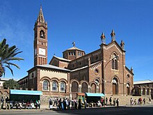
The city is known for its early 20th-century buildings, including the Art Deco Cinema Impero (opened in 1937 and considered by the experts one of the world's finest examples of Art Déco style building[27]), Cubist Africa Pension, eclectic Eritrean Orthodox Enda Mariam Cathedral and former Opera House, the futurist Fiat Tagliero Building, the neo-Romanesque Church of Our Lady of the Rosary, Asmara, and the neoclassical Governor's Palace.
The city is adorned by Italian colonial villas and mansions, one prominent example being the World Bank Building.
War cut this short, but his injection of funds created the Asmara of today, which supposedly was to be a symbol to the colonial fascism during that period of time.
Asmara has wide streets, restaurants, piazzas (town squares), bars and cafes while many of the boulevards are lined with palms trees.
The city has thousands of Art Deco, futurist, modernist, and rationalist buildings, constructed during the period of Italian Eritrea.
[32][33][34][35][36][37] The city, nicknamed "La piccola Roma" ("Little Rome"), is located over 2,000 meters above sea level, and was an ideal spot for construction due to the relatively cool climate; architects used a combination of both Italian and local materials.
A statement from UNESCO read: It is an exceptional example of early modernist urbanism at the beginning of the 20th century and its application in an African context.The Historic Center of Asmara was placed on the World Monuments Fund's 2006 Watch List of 100 Most Endangered Sites.
The listing was designed to bring more attention to the city to save the center from decay and redevelopment and to promote restoration.
Four big landmarks of the city are the Church of Our Lady of the Rosary and the Kidane Mehret Cathedral of the Catholic faith (the former of Latin and the latter of Coptic rite), the Enda Mariam Cathedral of the Eritrean Orthodox Tewahedo Church, and the Al Khulafa Al Rashiudin Mosque of the Islamic faith.
These districts are subdivided into North, North-West, North-East, South-East, South-West, East, West and Central areas.