Assinovskaya
The nearest settlements to Assinovskaya are Sernovodskoye in the north, Novy Sharoy in the east, Achkhoy-Martan in the south-east, Bamut in the south, and Berd-Yurt and Nesterovskaya in the west.
[8][9] According to official maps at the time, the aul and the village existed simultaneously, so on the map of the for 1871, there are the village of Assinskaya and the aul of Akhbarzoy, which is located on the opposite (right) bank of the Assa river, with Assinovskaya on the left, at the mouth of the Zheltukha stream.
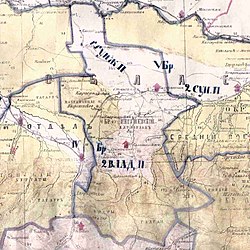
[10] According to the Regulations on the management of the Terek Oblast in 1862, the Ingushskiy Okrug was established as part of the Western Department.
It included societies of Nazranians, Karabulaks, Galgai, Kistins, Akkins and Tsorins[11] (also Meredzhin society and some Galanchozh and Yalkharoy auls[12]) which were ceded to Argunskiy Okrug [ru] in 1866 due to them belonging to the same nation as the locals (Chechens) and geographically closer to the central governance of the Okrug[13]).
About 30 attackers broke religious items, shot at the icons and images with machine guns, and raided the altar.