Atlanta Beltline
The Atlanta Beltline is designed to reconnect neighborhoods and communities historically divided and marginalized by infrastructure, improve transportation, add green space, promote redevelopment, create and preserve affordable housing, and showcase arts and culture.
"[3] Still under heavy use today, this railway segment begins near the Westside Provisions area, connects to the Atlanta Amtrak station, and continues northeast paralleling I-85 past Ansley Golf Club.
The map notes that this segment meets the Atlanta and Richmond Air-Line Railway line at a point labeled as "Belt Junction".
[8] The idea to turn the rail corridors into a ring of trails and parks originated in a 1991 proposal by the Georgia Rails-to-Trails Conservancy.
[9] In his 1999 master's degree thesis, Georgia Tech architectural student Ryan Gravel, proposed a version of the project that included fixed-rail transit without trail or parks.
in 2000, while working for an Atlanta architectural firm, Gravel and two of his colleagues, Mark Arnold and Sarah Edgens, summarized his thesis added in the earlier trails and parks concept, and mailed copies to two dozen influential Atlantans.
She, Gravel, Arnold, and Edgens spent the next several months promoting the idea of the Beltline to neighborhood groups, and Atlanta business and civic leaders.
Eventually, Woolard, by then City Council president, convinced Atlanta mayor Shirley Franklin, to support the idea.
But a series of studies of the idea, notable the Trust for Public Lands' "Beltline Emerald Necklace" report,[10] concluded that trails, greenways, affordable housing and zoning changes should be tackled before Gravel's proposed rail line.
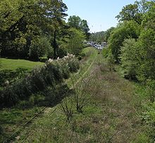
[14] The Beltline will feature a continuous path encircling the central part of the city, generally following the old railroad right of way, but departing from it in several areas along the northwest portion of the route.
In total, 33 miles (53 km) of multi-use paths are to be built, including spur trails connecting to neighborhoods.
[15] The PATH Foundation, which has many years of experience building such trails in the Atlanta area, is a partner in the development of this portion of the system.
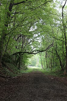
The Eastside Trail stretches from Piedmont Park in the north to Inman Park and Old Fourth Ward in the south, passing by the greatest concentration of industrial architecture in Atlanta adapted for residential reuse and as offices, retail, dining and shopping, the most notable example being Ponce City Market.
A completed and open portion links to the Eastside Trail near Krog Street Tunnel and continues southeast through Reynoldstown.
The 22-mile (35 km) light rail streetcar component of the Beltline plan was originally developed in 1999 as the central focus of a master's thesis by Georgia Tech student Ryan Gravel.
[25] The vision has expanded to include trails, parks and greenspace, streetscapes, public art, affordable housing, economic development, environmental sustainability, and historic preservation.
[citation needed] In 2016, City of Atlanta voters passed the More MARTA sales tax, providing $1.3 billion for the expansion of transit.
In late January 2009, GDOT and Amtrak made an unannounced and last-minute filing with the Surface Transportation Board that would effectively block the northeast part of the Beltline, instead taking it for future intercity rail.
[37][38][39] However, there are many supporters of the Beltline because it is responsible for revitalizing many Atlanta neighborhoods that were in decline, creating 50,000 permanent jobs, and bringing $10 billion of economic development to the city.