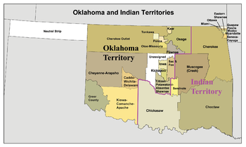
Atoka County, Choctaw Nation
Atoka County was a political subdivision of the Choctaw Nation of Indian Territory, prior to Oklahoma being admitted as a state.
Atoka was a leader before the Choctaw removed to the west of the Mississippi River; he was a co-signer of the Treaty of Dancing Rabbit Creek in 1830.
Its northern border skirted the Shawnee Hills to their south and connected with North Boggy Creek.
Atoka County served as an election district for members of the National Council; it was also a unit of local administration.
Constitutional officers, all of whom served for two-year terms and were elected by the voters, included the county judge, sheriff, and a ranger.
The sheriff collected taxes, monitored unlawful intrusion by intruders (usually white Americans from the United States), and conducted the census.
While Atoka County contained more sizable towns and industry than most, it would have to be dismantled in order to accommodate changes required by the region at large.