Aurland
The original municipality was identical to the Aurland parish (prestegjeld) with the sub-parishes (sokn) of Aurlandsvangen, Flåm, and Undredal.
The official blazon is "Azure, a goat buck's head erased argent" (Norwegian: På blå grunn eit avrive sølv geitebukkhovud).
The goat head has a tincture of argent which means it is commonly colored white, but if it is made out of metal, then silver is used.
As in all of western Norway, the area was overpopulated in the middle 19th century, and cotters were forced to clear land far up the mountainsides.
Tourists from England were dominant during this time and one can still find English names for mountaintops, hunting cabins, and fishing holes.
Three or four ships would anchor in the Nærøyfjord at a time which created the need for scores of horse-drawn carriages to take the tourists up to Stalheim hotel, located just over the border in Voss municipality to the southwest.
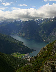
[34] Aurland lies 200 kilometres (120 mi) from the west coast of Norway in the eastern part of Vestland county, along the Aurlandsfjorden and the Nærøyfjorden.
Aurland is bordered by four municipalities in Vestland county: Lærdal to the north-east and Vik to the west, Voss to the south-west, and Ulvik to the south.
Wild and beautiful nature dominate the community from the fjords to mountaintops that are 1,200 to 1,800 metres (3,900 to 5,900 ft) above sea level.
Aurland has a typical inland climate with mild winters at the lower levels, early springs, and warm summers.
[11] The oldest bedrock in Aurland are Precambrian basement rocks which crop out in tectonic windows in the north-eastern part of the municipality.
The ice's advance was either halted or continued, according to the climatic conditions, and moraine ridges and gravel terraces were deposited along the glacier front.
[36] On the western side of the Aurlandsfjord, there is rock that was pushed up into mountain ranges several million years ago.
The West Norwegian Fjords of Geirangefjord and Nærøyfjord were added to UNESCO's World Heritage Site list in 2005.
The World Heritage Site possesses a unique combination of glacial landforms at the same time as each area is characterised by its own outstanding beauty.
This journey from Myrdal to Flåm is twelve miles long (19 km), a descent of 866 metres (2,841 ft).
To cope with the enormous change in height over such a short stretch, the track runs partly through tunnels which spiral in and out of the mountainside.
The gradient is quite exceptional for a normal railway and the carriages are fitted with five different brake systems, any one of which is sufficient to stop the train.
A document written in 1714 tells us that English merchants used to stay in Aurland during long periods to buy different articles and they are supposed to have taken part in the building of the church.