Highway 20 (Israel)
To solve these problems, as early as the 1950s, ideas were raised regarding using the route of the river as a transportation corridor, but it wasn't until the mid-1960s that the government began planning.
Previously, the northern terminus of the road was in Herzliya, but in January 2019 it was extended further north to near the kibbutz of Shefayim, where it has another connection to Highway 2 built as part of the Route 531 construction project.
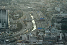
The southern part of the highway (i.e., the section passing through the Holon, Bat Yam and Rishon LeZion suburbs) was completed in 2012, including a second overpass in the Holon interchange and dual track railroad and six stations in the median of the highway (as part of a project which extended the Coastal Railway to Ashdod).
An east-west branch "Ayalon East", from Highway 4 to the Tel Aviv University railway station along the path of the Yarkon River has been planned, but is still not approved.
However, Israel Railways is in desperate need of adding a fourth railroad track in that area and no space exists to do so but "on top" of the river itself.
In 2018 a plan was finally approved to undertake a multi-billion Shekel project to add the fourth track although construction is not expected to commence until the early 2020s decade.
[4] Under construction as of 2020 are HOV lanes extending nearly the entire length of the Highway, together with large park & ride facilities located in the approaches to the Gush Dan region.