Ayer station
Land speculation and industrial development spurred by the railroad access expanded the tiny farm village into the independent town of Ayer.
After a brief disruption in early 1965, the Massachusetts Bay Transportation Authority began subsidizing commuter rail service to Ayer as part of what would become the Fitchburg Line.
[4] Ayer is a node for CSX Transportation freight service, with the Fitchburg Route serving as part of its main line.
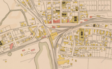
[7][8]: 27 The station was located on the southwest corner of the grade crossing, with a freight house just to its west and a woodshed (to supply early wood-burning locomotives) across the tracks.
[5][9][7] The Peterborough and Shirley Railroad (P&S), opened in February 1848, crossed the northern section of the W&N at grade and ran to the northwest.
[5] The line had originally been intended to meet the Fitchburg Railroad in Shirley to the west, but the terminus was changed to Groton to connected with the W&N.
[7] South Groton, until then "about a dozen farms of doubtful prosperity" and hindered by its remoteness, was quickly transformed by the railroads.
Industry, made possible by the railroad connections to major cities, soon arrived: a plow company in 1850, a tannery in 1854, and an iron foundry soon after.
The roof was rebuilt with new trusses; the former iron supporting pillars were used to construct the upper story of the nearby Spaulding Block.
[11] When the Hoosac Tunnel opened in 1875, trains through Ayer could run on the Fitchburg and the Vermont and Massachusetts Railroad as far west as Troy, New York.
The Brookline and Pepperell Railroad opened in 1894 and connected to the P&S in West Groton several miles to the north, with trains run through to Ayer.
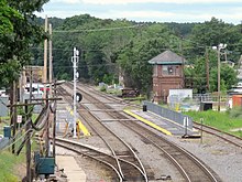
[8]: 19 An island platform was constructed around that time between the two Fitchburg main tracks east of the diamond crossing to serve commuters to Boston.
[17] Although Camp Devens opening in 1917 briefly increased traffic, competition from interurban streetcars (including a line on Central Street built around 1905) then automobiles in the early 20th century forced the B&M to discontinue service on marginal branch lines, as well as redundant routes built during years of intense competition between railroads.
[20] A small "modern railway depot" – likely just a bus shelter – was built around 1970; it was a noncontributing property to the Historic District.
[22][1] On December 27, 1976, the MBTA bought the B&M's northside commuter rail assets, including the entire length of the Fitchburg Line.
In 2003, the town and the Montachusett Regional Transit Authority (MART) began planning how to increase parking capacity.
However, the lot was delayed due to conflicts with businesses that would be displaced and the lack of a publicly owned pedestrian entrance (a requirement to use the federal funds).
[27][28][29] On April 28, 2014, pedestrian access to the station was partially cut off when the abutting landowner erected a fence on the station's primary access point, forcing riders to walk a short distance along the tracks to a different business lot, in an effort to stop commuters from parking on his business lots.
[19][28] In December 2014, the MBTA rejected a plan that would have created a pedestrian access path and a vehicle dropoff lane, alleging that the landowner had unfairly shifted property lines.
[31] In February 2015, the landowner again blocked station access due to commuters parking on his property after a series of snowstorms.
[36] In November 2016, MART agreed to pay for the demolition of the USO building; the town paid relocation costs for the two tenants.
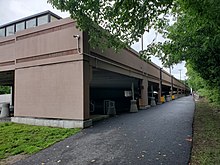
[41] An accessible sidewalk, kiss-and-ride lane / bus loop, and the Depot Square park were constructed next to the station in 2020–21 at the former USO building site.
However, with the parking issues settled and the accessible entry point in place, Ayer became eligible for a future reconstruction.