Baja California
It has an area of 70,113 km2 (27,071 sq mi) (3.57% of the land mass of Mexico) and comprises the northern half of the Baja California peninsula, north of the 28th parallel, plus oceanic Guadalupe Island.
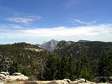
The backbone of the state is the Sierra de Baja California, where Picacho del Diablo, the highest point of the peninsula, is located.
The Kiliwa, Paipai, and Kumeyaay in the better-watered northwest were also hunter-gatherers, but that region supported denser populations and a more sedentary lifestyle.
Another group of people was the Guachimis, who came from the north and created much of the UNESCO World Heritage-recognized Sierra de Guadalupe cave paintings.
In 1751–1753, the Croatian Jesuit mission-explorer Ferdinand Konščak made overland explorations northward into the state of Baja California.
More importantly, the 1769 expedition to settle Alta California under Gaspar de Portolà and Junípero Serra resulted in the first overland exploration of the northwestern portion of the state.
They established a chain of new missions among the northern Cochimí and western Yumans, first on the coast and subsequently inland, extending from El Rosario (1774) to Descanso (1817), just south of Tijuana below the Palóu Line.
Mexican liberals were concerned that the Roman Catholic Church retained too much power in the post-independence period and sought to undermine it by mandating the secularization of missions in 1833.
In the aftermath of the Mexican American War (1846–1848) and the Treaty of Guadalupe Hidalgo, the United States gained sovereignty over territory previously held first by New Spain and then Mexico, most of which was sparsely settled.
In 1853, soldier of fortune (mercenary) William Walker captured La Paz, declaring himself president of the Republic of Baja California.
When liberal army general Porfirio Díaz came to power in 1876, he embarked on a major program to develop and modernize Mexico.
Temperate winds from the Pacific Ocean and the cold California Current make the climate along the northwestern coast pleasant year-round.
[18] As a result of the state's location on the California Current, rains from the north barely reach the peninsula, thus leaving southern areas drier.
The Cerro Prieto geothermal province is near Mexicali as well (this area is geologically part of a large pull apart basin); it produces about 80% of the electricity consumed in the state and enough additional power to export to California.
Guadalupe Island is located in the extreme west of the state's boundaries and is the site of large colonies of sea lions.
The Mediterranean climate is found in the northwestern corner of the state, where the summers are dry and mild and the winters cool and rainy.
The Mexicali Valley (which is below sea level) experiences the highest temperatures in Mexico, frequently surpassing 47 °C (116.6 °F) in mid-summer, and exceeding 50 °C (122 °F) on some occasions.
The fauna in the parks include a large number of mammals, primarily mule deer, bighorn sheep, cougars, bobcats, ringtail cats, coyotes, rabbits, squirrels and more than 30 species of bats.
[23] The main shock was felt as far as the Los Angeles, Las Vegas, Phoenix and Tucson metropolitan areas, and in Yuma.
During the 2018 Mexican general election, the presidential vote of Baja California was won by a landslide of almost 44% by Andrés Manuel López Obrador of the Morena party.
Mexicali has a large Chinese community, as well as many Filipinos who arrived to the state during the eras of Spanish Philippines and American rule (1898–1946) in much of the 19th and 20th centuries.
Those temporary residents awaiting their entry into the United States are called flotillas, which is derived from the Spanish word flota, meaning 'fleet'.
An estimated 200,000+ American expatriates live in the state, especially in coastal resort towns such as Ensenada, known for affordable homes purchased by retirees who continue to hold U.S. citizenship.
[30] According to a Consejo Nacional de Ciencia y Tecnología (Conacyt) investigator, a little under a million people were classified as "poor" in the state, up from 2008 when there were roughly 810,000.
The state government provides education and qualification courses to increase the workforce standards, such as school–enterprise linkage programs which help the development of a labor force according to the needs of the industry.
These universities have 19 research and development centers for basic and applied investigation in advanced projects related to biotechnology, physics, oceanography, computer science, digital geothermal technology, astronomy, aerospace, electrical engineering and clean energy, among others.
Baja California has developed a need to be self-sufficient in matters of technological and scientific innovation and to be less dependent on foreign countries.
[34][full citation needed] Baja California's economy has a strong focus on tariff-free export oriented manufacturing (maquiladora).
About 81.4% of Baja California's foreign domestic investment comes from the United States, of which 50.3% comes from the construction of natural gas pipelines and 8.2% comes car and truck manufacturing.
[39] In 1973, in order to bring in more foreign tourist investment, the Bank Trust of Fideicomiso was created, thus allowing non-Mexicans to own land without any constitutional amendment necessary.