Chiapas
On the several parallel sierras or mountain ranges running along the center of Chiapas, the climate can be quite moderate and foggy, allowing the development of cloud forests like those of Reserva de la Biosfera El Triunfo, home to a handful of horned guans, resplendent quetzals, and azure-rumped tanagers.
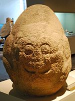
[18] Mayan civilization in the Lacandon area is marked by rising exploitation of rain forest resources, rigid social stratification, fervent local identity, waging war against neighboring peoples.
The isolation of Chiapas from centers of power, along with the strong internal divisions in the intendencia caused a political crisis after the royal government collapsed in Mexico City in 1821, ending the Mexican War of Independence.
The more radical of these even allowed indigenous groups the religious freedoms to return to a number of native rituals and beliefs such as pilgrimages to natural shrines such as mountains and waterfalls.
[26][38] The Porfirio Díaz era at the end of the 19th century and beginning of the 20th was initially thwarted by regional bosses called caciques, bolstered by a wave of Spanish and mestizo farmers who migrated to the state and added to the elite group of wealthy landowning families.
[15] Rabasa also introduced the telegraph, limited public schooling, sanitation and road construction, including a route from San Cristóbal to Tuxtla then Oaxaca, which signaled the beginning of favoritism of development in the central valley over the highlands.
The last of the Mapache resistance was overcome in the early 1930s by Governor Victorico Grajales, who pursued President Lázaro Cárdenas' social and economic policies including persecution of the Catholic Church.
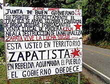
[47] In Chiapas poor farmland and severe poverty afflict the Mayan Indians which led to unsuccessful non violent protests and eventually armed struggle started by the Zapatista Army of National Liberation in January 1994.
The border between Mexico and Guatemala had been traditionally poorly guarded, due to diplomatic considerations, lack of resources and pressure from landowners who need cheap labor sources.
[50] The arrival of thousands of refugees from Central America stressed Mexico's relationship with Guatemala, at one point coming close to war as well as a politically destabilized Chiapas.
[45] Although the Zapatista movement couched its demands and cast its role in response to contemporary issues, especially in its opposition to neoliberalism, it operates in the tradition of a long line of peasant and indigenous uprisings that have occurred in the state since the colonial era.
[58] The major reason for this was that the rebellion caught the attention of the national and world press, as Marcos made full use of the then-new Internet to get the group's message out, putting the spotlight on indigenous issues in Mexico in general.
[61] Many[quantify] blamed the unrest on infiltration of leftists among the large Central American refugee population in Chiapas,[62] and the rebellion opened up splits in the countryside between those supporting and opposing the EZLN.
Eventually, the activities of the Zapatistas began to worry the Roman Catholic Church in general and to upstage the diocese's attempts to re establish itself among Chiapan indigenous communities against Protestant evangelization.
One reason for this was the December 1997 massacre of forty-five unarmed Tzotzil peasants, mostly women and children, by a government-backed paramilitary in the Zapatista-controlled village of Acteal in the Chenhaló municipality just north of San Cristóbal.
[58] The revolt also pressed the government to institute anti-poverty programs such as "Progresa" (later called "Oportunidades") and the "Puebla-Panama Plan" – aiming to increase trade between southern Mexico and Central America.
Environmental groups state that the settlements pose grave risks to what remains of the Lacandon, while the Zapatistas accuse them of being fronts for the government, which wants to open the rainforest up to multinational corporations.
[77] The Lacandon Jungle is situated in north eastern Chiapas, centered on a series of canyonlike valleys called the Cañadas, between smaller mountain ridges oriented from northwest to southeast.
[20] The most numerous of these Mayan groups include the Tzeltal, Tzotzil, Ch'ol, Zoque, Tojolabal, Lacandon and Mam, which have traits in common such as syncretic religious practices, and social structure based on kinship.
These include Bochil, Sitalá, Pantepec, Simojovel to those with over ninety percent indigenous such as San Juan Cancuc, Huixtán, Tenejapa, Tila, Oxchuc, Tapalapa, Zinacantán, Mitontic, Ocotepec, Chamula, and Chalchihuitán.
[102] Most Indigenous communities have economies based primarily on traditional agriculture such as the cultivation and processing of corn, beans and coffee as a cash crop and in the last decade, many have begun producing sugarcane and jatropha for refinement into biodiesel and ethanol for automobile fuel.
On market day, many indigenous people from rural areas come into San Cristóbal to buy and sell mostly items for everyday use such as fruit, vegetables, animals, cloth, consumer goods and tools.
It was common for politicians, especially during Institutional Revolutionary Party's dominance to visit here during election campaigns and dress in indigenous clothing and carry a carved walking stick, a traditional sign of power.
[42][60] Recently there has been political, social and ethnic conflict between the Tzotzil who are more urbanized and have a significant number of Protestant practitioners and the Tzeltal who are predominantly Catholic and live in smaller farming communities.
[122] The Mams are a Mayan ethnicity that numbers about 20,000 found in thirty municipalities, especially Tapachula, Motozintla, El Porvenir, Cacahoatán and Amatenango in the southeastern Sierra Madre of Chiapas.
Major crops include corn, beans, sorghum, soybeans, peanuts, sesame seeds, coffee, cacao, sugar cane, mangos, bananas, and palm oil.
Noted 20th-century artists include Lázaro Gómez, Ramiro Jiménez Chacón, Héctor Ventura Cruz, Máximo Prado Pozo, and Gabriel Gallegos Ramos.
[145] President Vicente Fox voiced concerns about the influence of the fundamentalism and possible connections to the Zapatistas and the Basque terrorist organization Euskadi Ta Askatasuna (ETA), but it appeared that converts had no interest in political extremism.
[147] In San Cristóbal, the Murabitun established a pizzeria, a carpentry workshop[148] and a Quranic school (madrasa) where children learned Arabic and prayed five times a day in the backroom of a residential building, and women in head scarves have become a common sight.
[87] The capital of Sak Tz’i’ (an Ancient Maya kingdom) now named Lacanja Tzeltal, was revealed by researchers led by associate anthropology professor Charles Golden and bioarchaeologist Andrew Scherer in the Chiapas in the backyard of a Mexican farmer in 2020.