Oaxaca
Most live in the Central Valleys region, which is also an economically important area for tourism, with people attracted for its archeological sites such as Monte Albán, and Mitla,[10] and its various native cultures and crafts.
[16] The diet developed around this time remained until the Spanish Conquest, consisting primarily of harvested corn, beans, chocolate, tomatoes, chili peppers, squash and gourds.
[16] Starting from AD 750 previous large urban centers such as Monte Alban fell across the Oaxaca area and smaller dominions grew and evolved until the Spanish Conquest in 1521.
The valley Zapotecs, the Mixtecs of the Upper Mixteca, the Mazatecas and the Cuicatecas, for the most part, chose not to fight the newcomers, instead negotiating to keep most of the old hierarchy but with ultimate authority to the Spanish.
He was followed by Bartolome de Olmade and others who began the superficial conversion of a number of indigenous people, including the baptism of Zapotec leader Cosijoeza.
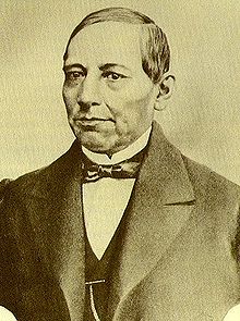
The capital was later recaptured by the liberals under Carlos Oronoz, but soon after Juárez took back the presidency, Díaz declared rebellion against him from Oaxaca in 1872 under the Plan de Tuxtepec.
[16] During Díaz's rule, called the Porfiriato, a number of modernization efforts were undertaken in the state, such as public lighting, first with gas then with electricity, railroad lines, new agriculture techniques and the revitalization of commerce.
Various leaders such as Francisco I. Madero, Victoriano Huerta and Venustiano Carranza came to the state during this time, but the most important force in the area was the Liberation Army of the South under Emiliano Zapata.
Major elevations in the state include Zempoaltepetl (3,396 m or 11,142 ft asl), El Espinazo del Diablo, Nindú Naxinda Yucunino and Cerro Encantado.
[38] Conservation efforts in the state are hampered by high marginalization, lack of economic alternatives, agricultural conflicts, change of land use (agricultural activities, fires), over-exploitation and pollution of natural water sources, inadequate forest management and illegal tree felling, unsustainable coastal tourist developments, climate change, limited local capacity, and limited local knowledge and valuation of natural resources.
[40] The park has 10 different types of vegetation: "selva espinosa", swampland, deciduous, sub-tropical broadleaf, mangrove, savannah, "bosque de galleria", "tular", palm trees, and coastal dunes.
There are 16 ethno linguistic groups recognized by the Instituto Nacional Indigenista[52] who maintain their individual languages, customs and traditions well into the colonial period and to some extent to the present day.
The Zapotec language has historically been and is still the most widely spoken in the state, with four dialects that correspond to the four subdivisions of these people: Central Valleys and Isthmus, the Sierra de Ixtlan, Villa Alta and Coapan.
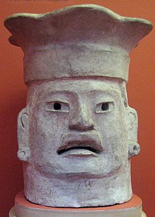
[attribution needed][56][57] With development of agricultural practices, with maize as the main crop and settled villages getting established over several centuries, a warrior type of societal culture evolved by 500 BC, with the Zapotec state getting into shape.
In subsequent years, as upper strata of society (an "elite class") came into existence, the religious practices and the temple got more formalized with priests controlling the community's religion.
[56][57] Richard Sosis, an anthropologist at the University of Connecticut has summarised the archaeological findings with the observation:[56] the Michigan archaeologists' study delineated the process of religion adapting to different environments as Oaxacan society changed.
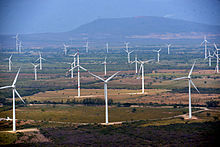
[24] The state government has been pushing this sector heavily as a means of growing the economy,[24] with major infrastructure projects such as the Oaxaca-Puerto Escondido-Huatulco highway (scheduled to finish in 2018) and the Iberdrola hydroelectric dam.
Airlines that fly to the state include Aeroméxico, Volaris, Interjet, and VivaAerobus arriving from Mexico City, Cancun, Guadalajara, Monterrey, and Tijuana.
[76] The state has not produced as many writers as painters but some important names include Adalberto Carriedo, Jacobo Dalevuelta, Andrés Henestrosa and Natalia Toledo.
The popular bitter chocolate drink, traditionally served cold in special cups (xicali) with a variety of spices, was once a favorite beverage among the upper classes of Mesoamerican societies.
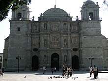
This area is the cultural, geographical and political center of the state, filled with pre-Hispanic ruins, Baroque churches and monasteries, indigenous markets and villages devoted to various crafts.
[80] Hierve el Agua is an area with "petrified" waterfalls, where water with extremely high mineral content falls over the side of cliffs, forming stone waterfall-like structures.
[24] The second most important zone for tourism is the coast, especially from Puerto Escondido to Huatulco, with sandy beaches on the Pacific Ocean, dolphins, sea turtles, and lagoons with water birds.
[24] There are also areas of Oaxaca that are promoted for ecotourism such as Lagunas de Chacahua National Park set in 14,267 hectares of lagoons, rivers, beaches, mangroves, rainforest and grasslands with some 136 species of birds, 23 of reptiles, 4 amphibians and twenty types of mammals.
[24] Yagul Natural Monument, located in the Tlacolula Valley, 35 km to the east of Oaxaca city, was a settlement in the early part of the Monte Alban 1 Period (500 CE).
Oaxacan handcrafts are traditionally made with wood, wool, clay and leather and are sold in many venues from local tianguis markets to upscale international stores.
[clarification needed] The coat of arms consists of a red canvas, wrapped around its upper end; inside within a white oval is the inscription "EL RESPETO AL DERECHO AJENO ES LA PAZ" (Respect for the rights of others is peace), and the slogan words are separated from each other by symbolic representations of nopales.
[98] There are 1,020 primary care medical facilities and 28 hospitals in the state, 3,240,024 people are registered in one or more government programs and are attended by 3,337 doctors, 5,400 paramedics and 6,887 other health providers.
[104] In 2022, amidst soaring rates of obesity and diabetes, Oaxaca enacted a ban on sugary drinks, including notably Coca-Cola, but it was poorly enforced.
[108] Vinicio Castilla is the most notable player hailing from Oaxaca, having played third base in Major League Baseball for the Atlanta Braves, Colorado Rockies, Tampa Bay Devil Rays, Houston Astros and San Diego Padres.