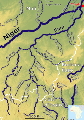
Bani River
The drainage basin upstream of Douna has an area of 102,000 km2 (39,000 sq mi), 85% of which lies in southern Mali and 15% in northern Côte d'Ivoire.
The drought that started at the beginning of the 1970s led to a very large reduction in the flow and up to the present time the volumes are still much lower than those observed in the 1950s and 1960s.
Over the same period the catchment basin of the Upper Niger suffered a similar 20% reduction in rainfall but the readings at the Koulikoro gauge station were only reduced to 50% of the earlier values.
[8] Because of the accumulated groundwater deficit, even in a year with high rainfall, the discharge of the Bani River is less than in the wet decades of the 1950s and 1960s.
[7] In 2006 the Talo Dam was constructed to irrigate parts of the floodplain to the south of the river near the town of San.
Prior to the construction of the dam, these areas were only fully flooded in very wet years, the most recent of which occurred in 1967.
In May 2009 the African Development Bank approved funding for an irrigation dam/weir to be built on the Bani near Soala, a village situated 12 km (7.5 mi) south of Djenné.