Brecon Beacons National Park
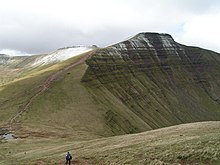
The national park includes the highest mountain in South Wales, Pen y Fan, which has an elevation of 886 metres (2,907 ft).
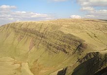
These ranges share much of the same basic geology, the southerly dip of the rock strata leading to north-facing escarpments.
[9] In a paragraph on Brecknockshire, John Leland's 1536–1539 Itinerary notes that: Blak Montayne is most famose, for he strecchith, as I have lerned, his rootes on one side within a iiii.
The Black Mountains in the east are clearly separated from the central Beacons range by the Usk valley between Brecon and Abergavenny.
The Brecon Beacons range, Fforest Fawr, and Black Mountain form a continuous massif of high ground above 300 metres (1000').
The area was inhabited during the Neolithic and the succeeding Bronze Age, the most obvious legacy of the latter being the numerous burial cairns which adorn the hills of the centre and west of the National Park.
[23] The area played a significant role during the Industrial Revolution as various raw materials including limestone, silica sand and ironstone were quarried for transport southwards to the furnaces of the industrialising South Wales Valleys.
[citation needed] The Brecon Beacons Mountain Centre was opened in 1966 to help visitors understand and enjoy the area.
Common ravens, red kites, peregrine falcons, northern wheatears, ring ouzels, and the rare merlin breeds in the park.
[32] Outdoor activities in Brecon Beacons National Park include walking, cycling, mountain biking and horse riding, as well as sailing, windsurfing, canoeing, fishing, rock climbing, hang-gliding, caravanning, camping and caving.
A long-distance cycling route, the Taff Trail, passes over the Beacons on its way from Brecon to Cardiff, and in 2005 the first walk to span the entire length of the park was opened.
The 99-mile (159 km) route, called the Beacons Way, runs from Abergavenny via The Skirrid (Ysgyryd Fawr) in the east and ends in the village of Llangadog in Carmarthenshire in the west.
The railway's starting point at Pant is located two miles (3 km) north of Merthyr Tydfil town centre.
Their work is not restricted to mountain rescue – they frequently assist the police in their search for missing or vulnerable people in the community.The Brecon Beacons are used for training members of the UK armed forces and military reservists.
An army captain had been found dead on Corn Du earlier in the year after training in freezing weather for the SAS.
[34] On 17 April 2023 it was announced that the National Park had officially adopted the name Bannau Brycheiniog in both Welsh and English.
[39][40][41] The plan for the park to become net zero by 2035[18] and to address environmental concerns was supported by Welsh actor Michael Sheen.
[40][41] Upon the news of the name change the Prime Minister Rishi Sunak stated "I'm going to keep calling it the Brecon Beacons, and I would imagine most people will do that too.
"[44] Catherine Mealing-Jones, the park authority's CEO, stated: "the name Brecon Beacons doesn't make any sense – the translation Brecon Beacons doesn't really mean anything in Welsh", adding that "a massive carbon-burning brazier is not a good look for an environmental organisation".
The campaigners say the decision did not respect Wales as a bilingual nation as it did not treat English and Welsh languages equally, and ambassadors of the park were not consulted on the name change.