Bas-Saint-Laurent
The name of the bay was used again to describe the river when the Narration, his report of his expedition, was translated to Spanish and Italian, and definitively fixed by its use in the world map of cartographer Gerardus Mercator in 1569, according to historian Marcel Trudel.
In their Histoire du Bas-Saint-Laurent, the historians Fortin and Lechasseur assert that the relation with the Saint Lawrence grew with the population of the region in the 19th century.
The first mention of the name is attributed to a report from the Rimouskois deputy and writer Joseph-Charles Taché, which used the term to describe "the two shores of the Bas-Saint-Laurent except the Gaspé district".
[4] Even if the name of the region was present on a map made in 1863 by Stanislas Drapeau, it took time to settle in; the expression "le Bas du Fleuve" being preferred.
The magma surfacing mixed with the sediments originating from the continental erosion and the volcanic arc of islands got gradually closer to the continent to the subduction.
They are concentrated in the Precambrian bedrock under the Logan line and the Appalachian Mountains, at a variable depth between 30 km (19 mi) deep and the surface[15] Another seismic area located in the Gulf of Saint Lawrence, in a triangle between the towns of Matane, Baie-Comeau and Sept-Îles.
The main species of trees within it are the paper birch, the balsam fir, and the white spruce, as well as rarer quaking aspens and jack pines.
[30] However, a more profound analysis of the composition of the forests of Bas-Saint-Laurent allows to shed light on which trees grow at which elevations, type of soils and latitudes.
[33] The melting of the ice sheet and the flood of the sea of Goldthwait around the current estuary brought molluscs like true mussels, soft-shell clams and scallops.
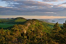
The Lac-Témiscouata National Park is located east of the Lake Témiscouata and protects a representative part of the Notre Dame Mountains and several ancient forests.
It holds the longest fjord in the east of Canada as well as a part of the largest estuary in the world, which makes it a location of considerable marine biodiversity.
[40] After reaching its peak in the middle of the 20th century due to the strong natality and a reduction of child mortality, the population of Bas-Saint-Laurent has declined over the last 50 years.
[45] The regional conference of elected representatives considers immigration to be a major issue for the economic and social development of Bas-Saint-Laurent and expends great efforts to attract new inhabitants, it also creates programs of insertion and promotion for them.
[48][49] According to the most recent demographic projection from the Institut de la statistique du Québec, the population of Bas-Saint-Laurent will register a slight decline to 198,600 in 2031.
[50] The first inhabitants of the area that is now known as Bas-Saint-Laurent lived on the shore of the estuary soon after the glaciers melted[51] Archeological excavations between 1980 and 1990 around Bic and Rimouski indicate an amerindian presence during the Paleoindian, between 9,000 and 8,000 BP years, according to Pierre Dumais and Gilles Rousseau.
[52] Paleoindian sites discovered on an ancient beach 80 m (260 ft) above and a sea shelf contained stone tools and lithic flakes, indicating an industry belonging to the Plano culture.
Aside from tools and lithic flakes, archeologists also found broken and heated stones, sign that the inhabitants created hearths with which they cooked food and maybe smoked the meat.
When conquered, around 1760, the population east of Kamouraska is composed of a couple dozen families of pioneers and is concentrated in four seignories : Rivière-du-Loup, Isle-Verte, Trois-Pistoles and Rimouski.
[60] The construction of the Chemin du Portage around 1783 which allowed to link the valley of the Saint-Laurent with the British colonies of the Maritimes, which makes the area less isolated, but doesn't induce any permanent settlement alongside its path.
The first parish of Bas-Saint-Laurent east of Kamouraska is Cacouna, created in 1825, a century and a half after the arrival of the first un siècle et demi après l'arrivée des premiers pioneers.
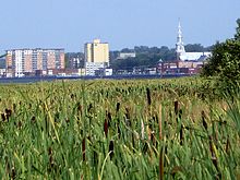
Second, entrepreneurs like William Price establish sawmills which creates opportunities of employment for factory and forest workers, favorable trade with the United Kingdom and the United States allows this industry to profit with their exports finally, Rimouski turns into a regional centre of services with the establishment of a courthouse in 1862, the creation of the diocese of Rimouski in 1867 and the opening of a seminar in 1871.
This change in the regional economy will negatively impact the hinterland, whose population reinforces Rimouski and the neighboring towns, like Saint-Anaclet-de-Lessard and the old municipalities of Le Bic, Rimouski-Est and Pointe-au-Père.
[63] In reaction to this rural flight, the federal and provincial governments establish in the 1960s, a test program of spatial planning in the regions of Gaspésie and Bas-Saint-Laurent.
The Bureau d'aménagement de l'Est du Québec (BAEQ) is created in 1963 and the planners work for three years on a plan to raise the quality of life of the population by notably improving the mobility and formation of the workforce.
It is the eastern end of the autoroute 20 since 2008,[79] The city contains a train station and Mont-Joli Airport operating regular flights to Montreal, Quebec, Côte-Nord and the Magdalen Islands.
[8] Since the start of the 20th century, the region is turning towards the second and third transformations[97] of its resources and is attempting to create new markets, notably in marine technology and biotechnology, environmentally friendly construction and peat usage.
[99] The Institut de la statistique du Québec reports that the gross domestic product of the region was of 5 billions in 2009, registering a growth of 1.3% compared to the previous year.
[42] Even Bas-Saint-Laurent is located at the 13th place among the 17 regions of Quebec in GDP per capita, it sports an unemployment rate of 8.0% in 2011, a figure in decline of 2% compared to the previous year.
The signs of this new reality in the workforce are already apparent, as Secor notes, taking as an example the thirty programs of professional and technic formations that struggle to recruit enough students.
This is notably the case for Enercon and other companies of the wind industry in Matane[97] and the factory of Bombardier Transportation at La Pocatière, which will fulfill an assembly contract of rolling stocks for the cities of Montreal and New York.