Basin and range topography
[1][2] The extension results in the thinning and deformation of the upper crust, causing it to fracture and create a series of long parallel normal faults.
As the crust thins, it also allows heat from the mantle to more easily melt rock and form magma, resulting in increased volcanic activity.
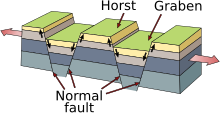
[3] With crustal extension, a series of normal faults which occur in groups, form in close proximity and dipping in opposite directions.
[6] The tectonic mechanisms responsible for lithospheric extension in the Basin and Range province are controversial, and several competing hypotheses attempt to explain them.
[14] Though the Aegean Sea Plate is more difficult to study because it is underwater, efforts have been made to conduct GPS surveys of the seafloor and surrounding area.
[15] The plate's deformation is thought to be a result of crustal collapse (beginning c. 14 Ma) combined with slab rollback on the Hellenic Subduction Zone.