Basin and Range Province
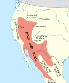
The Basin and Range Province is a vast physiographic region covering much of the inland Western United States and northwestern Mexico.
The province extends north to the Columbia Plateau and south as far as the Trans-Mexican Volcanic Belt in Mexico, though the southern boundaries of the Basin and Range are debated.
[3] Common geographic features include numerous endorheic basins, ephemeral lakes, plateaus, and bolson valleys alternating with mountains (as described below).
The average crustal thickness of the Basin and Range Province is approximately 30–35 km and is comparable to extended continental crust around the world.
"[8] The tectonic mechanisms responsible for lithospheric extension in the Basin and Range province are controversial, and several competing hypotheses attempt to explain them.
[9] The movement at this boundary divided the Pacific-Farallon Ridge and spawned the San Andreas transform fault, generating an oblique strike-slip component.
[10] Today, the Pacific plate moves north-westward relative to North America, a configuration which has given rise to increased shearing along the continental margin.
[11] The western United States is a region of high heat flow which lowers the density of the lithosphere and stimulates isostatic uplift as a consequence.
Since then, similar deformational patterns have been identified in MCCs in the Basin and Range and has led geologists to examine them as a group of related geologic features formed by crustal extension during the Cenozoic era (66.0 million years ago to present).
[15] Prior to the Eocene Epoch (55.8 ±0.2 to 33.9 ±0.1 Ma) the convergence rate of the Farallon and North American plates was fast, the angle of subduction was shallow, and the slab width was huge.
[16][17][18][19] In addition to small amounts of Nevada petroleum, the Basin and Range Province supplies nearly all the copper and most of the gold, silver, and barite mined in the United States.