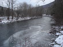
Batten Kill
The Batten Kill valley is home to the Tour of the Battenkill, the largest road cycling race in North America.
[4] The Batten Kill rises in East Dorset, Vermont, and flows south, with Mad Tom Brook soon joining it from the southern slope of Mount Tabor.
The river continues west, forming the boundary between the towns of Jackson and Salem, turning north at the hamlet of Shushan.
The Batten Kill continues as the boundary between Greenwich and the town of Easton, past the hamlet of Middle Falls and ends at the Hudson River, at a point one mile (1.6 km) north of Schuylerville.
Mad Tom Brook rises on the southern slope of Mount Tabor in the northwestern part of the town of Peru at an altitude of 2,900 feet (880 m) above sea level.
It flows southward and south-westward to East Dorset where it joins the beginning of the Batten Kill from the north.
The West Branch rises on the northern slope of Bear Mountain in the southeastern part of the town of Rupert at an altitude of about 2,500 feet (760 m) above sea level.
Camden Creek flows south to southwest from its source, just east of the New York state line, near West Sandgate.
The Batten Kill was supposed to be a fallback point for the British General Burgoyne's forces, but was never used and thus did not play a significant role in the battle.