Battle of Messines (1914)
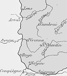
West of a line between Arras and Calais in the north-west, lay chalk downlands, covered with soil sufficient for arable farming.
East of the line, the land declines in a series of spurs into the Flanders plain, bounded by canals linking Douai, Béthune, St. Omer and Calais.
From Kemmel, a low ridge lay to the north-east, declining in elevation past Ypres, through Wytschaete, Gheluvelt and Passchendaele, curving north and then north-west to Diksmuide, where it merged with the plain.
Inland the ground was mainly meadow, cut by canals, dykes, drainage ditches and roads built up on causeways.
The Lys, Yser and upper Scheldt had been canalised and between them the water level underground was close to the surface, rose further in the autumn and filled any dip, the sides of which then collapsed.
The ground surface quickly turned to a consistency of cream cheese and on the coast troops were confined to roads, except during frosts.
South of La Bassée Canal around Lens and Béthune was a coal-mining district full of slag heaps, pit-heads (fosses) and miners' houses (corons).
North of the canal, the city of Lille, Tourcoing and Roubaix formed a manufacturing complex, with outlying industries at Armentières, Comines, Halluin and Menin, along the Lys river.
In France, the roads were closed by the local authorities during thaws, to preserve the surface and marked by Barrières fermėes signs, which were ignored by British lorry drivers.
The difficulty of movement after the end of summer absorbed much of the local labour on road maintenance, leaving field defences to be built by front-line soldiers.
On 12 October, the British cavalry advanced and found the Germans dug in on Mont des Cats and at Flêtre, on the road from Cassel to Bailleul.
A foothold was gained at Warneton and German outposts at Houthen and Hollebeke, west of the Ypres–Comines canal, were pushed back to the far side.
[8] The cavalry advanced towards the Lys between Houplines and Comines at 6:00 a.m. in fog, which grounded Royal Flying Corps (RFC) reconnaissance aircraft and made artillery support impossible.
[9] A German attack threatened the left flank of the 1st Cavalry Division (Major-General Beauvoir De Lisle), which held its position on Messines Ridge despite substantial casualties.
The German 26th Württemberg Division began its offensive at 4:30 a.m. and broke into Messines after nearly five hours of fighting, the 6,000 men of Infantry Brigade 51 facing fewer than 900 British cavalry.
Despite heavy shelling by German guns from 6:00 a.m., no infantry assault took place until 2:45 p.m., due to the advance of II Corps on the right (south) of the 2nd Cavalry Division into the Bavarian flank.
The ridge between the town and Messines was held by 600 men of the 6th Dragoon Guards and survivors of the London Scottish Regiments, against six German battalions, odds of 12:1.
Both were steadily forced back from their positions at the towns and ridge lines by 4:00 a.m. At 6:00 a.m. another German infantry attack developed.
The front fell quiet, action being limited to raids by both sides and heavy shelling of Ypres by German artillery.
[15] The French had been able to use the undamaged railways behind their front, to move troops more quickly than the Germans, who had to take long detours, wait for repairs to damaged tracks and replace rolling stock.
[16] The French had been able to move troops in up to 200 trains per day and use hundreds of motor-vehicles, co-ordinated by two staff officers, Commandant Gérard and Captain Doumenc.