Battlefield archaeology
[2] It is not considered distinct from Military archaeology or Recceology (i.e., the recovery of surface finds and non-invasive site surveying).
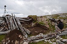
Between 2006 and 2008 the Council for British Archaeology conducted a resource assessment for English Heritage, creating a database of more than 200 battlefields in England.
[2] Depending on the time period of the battlefield being studied, earthwork surveys will exhibit varying degrees of success.
These instruments have the ability to identify the irregularity (artifact, bone, wall) and omit any other background material such as dirt or naturally occurring elements.
[2] Ground-penetrating radar sends out electromagnetic radiation pulses to detect and then reflect signals from subsurface structures.
This process requires little expertise and minimal equipment as long as grid mapping is very effective and accurate.
[2] Desk-top assessments are performed by searching through text based documents pertaining to the site in question.
The issue with desk-top assessments is that depending on the historical context, certain international conflicts can vary in accuracy.
[2] The First World War exhibited a conflict that mobilised large numbers of soldiers and a sophisticated and diverse array of material culture.
It also concerns the study of material culture associated with individuals: including 'trench art', such as engraved shells and the personal belongings of private soldiers, officers and civilian staff.
The project looked for the militarised footprint of the conflict, basing its conclusions on trench systems, army camps and the refuse of forces (small-finds including coins, bullets and other military gear).
Excavations on the Western Front often occur for humanitarian reasons, namely the recovery and identification of human remains and the disposal of unexploded ordnance.
For example, during the first five hours of the Kaiserschlacht ('German spring offensive'), over one million shells were fired by the Germans into the Allies' lines across the entire 150-mile front.
A study conducted at the Ypres battlefield in 2008 concluded that the highest level of copper contamination of the soil was over 200mg/kg, which was higher than the background threshold of 17mg/kg.
The French Government created Département du Déminage for the purpose of collecting and detonating unexploded ordnance in the Red Zone.
Additionally, bombardment creates large craters and mixes the soil layers together in unique ways.
[13] As a result, methods of stratigraphic analysis must take into account this unique phenomenon when analyzing a site related to World War I.
A noteworthy burial site contains the remains of thirty-one British soldiers at Le Pont de Jure.
It is thought that these soldiers died in April 1917 during successful British assaults on the German trenches in the area.
Two bodies show evidence of having been victims of artillery or other high explosives, with only one arm, one leg, and half a skull between the two of them.