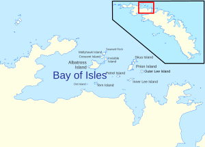
Bay of Isles
It was discovered in 1775 by a British expedition under James Cook and so named by him because numerous islands (at least twelve) lie in the bay.
Its northernmost point is the rugged headland Cape Buller; Cleveland Rock sits nearby.
[6][7] Along the coast to the west are Sheathbill Bay, separated by a small cove from Rosita Harbour.
[8][9] Ram Head separates Rosita Harbour from Camp Bay to the south.
It is tussock-covered at the higher levels, and backed by 35 m (115 ft) cliffs which extend eastward from Markham Point.
[19] East of the beach, Grace Glacier flows into Ample Bay, marking the west side of Salisbury Plain; Lucas Glacier marks the plain's east side.
[20][21] Continuing east along the south coast of the bay, Luck Point forms the west side of the entrance to Sea Leapord Fjord, a large fjord 1.15 nmi (2.13 km) wide, bordered on the east side by Bellingshausen Point.
[22][23][24] Immediately east is Beckmann Fjord, whose easternmost side is marked by Daisy Point.
[28] Finally, the farthest east side of the Bay of Isles is marked by Cape Wilson.
[28][7][10][12] The South Georgia Survey (SGS) of 1951-1957 has been responsible for selecting several names in and around the Bay of Isles.