Protector Shoal
The seamount erupted in 1962, probably during March, and produced a large pumice raft that was swept by ocean currents around Antarctica.
[8] Submarine volcanoes lie at each end of the chain: Protector at the northern, Nelson and Kemp at the southern.
[4] The northern slopes of the common ridge have a low gradient and are cut by numerous faults associated with the subduction process.
[13] The ridge is topped by about seven distinct seamounts[2] that are referred to in the literature as:[3] Tula ("PS1"), Biscoe ("PS2"), "PS3", Protector Shoal ("PS4"), Endurance ("PS5"), JCR ("PS6") and Quest ("PS7").
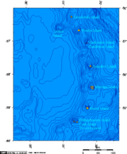
[12] The shallowest point of the chain is Protector Shoal which reaches a depth of 55 metres (180 ft) below sea level.
[3] Dives on to Quest and Protector Shoal have found a seafloor covered with gravel, sediments, talus and volcanic blocks that reach metre sizes.
The oceanic crust under the arc is young, only about 8–10 million years, and formed on the Scotia spreading ridge west of the South Sandwich Islands.
[26] Phenocrysts include amphibole, augite, diopside, ilmenite, orthopyroxene, plagioclase, quartz and titanium-containing magnetite.
The crustal rocks are most likely the product of island arc volcanism rather than spreading at the Scotia Ridge, although the latter possibility cannot be ruled out.
[29] Melts derived from subducted sediments played no role in the formation of Protector Shoal magmas.
Bryozoans, crinoids, various species of octocorals, serpulid worms, sponges and starfish colonize exposed rocks.
[38] The Nimrod Bank is relatively more recent,[14] and the lack of dropstones in dredges and pumice samples implies that most of Protector Shoal is less than 10,000 years old.
[41] There is present-day hydrothermal venting,[5] inferred from temperature anomalies during dives on to Quest caldera, Protector Shoal and Scoresby Seamount.
Thermal anomalies at Protector are concentrated in a small depression in the collapse scar,[38] no vent sites have been identified.
[13] The ship progressed through a denser raft with larger pumice blocks as it sailed north towards and past Zavodovski.
[43] The raft consisted of many streams of pumice blocks[44] and covered an area exceeding 5,000 square kilometres (1,900 sq mi).
[13] The pumices have been classified in two groups, a white bubble-rich one and a grey bubble-poor one, with slightly distinct chemical compositions.
[54][56][60] Pumice samples derived from Protector Shoal have been recovered from Livingstone Island in the South Shetland Islands and Rio Bueno on Tierra del Fuego [61] at the tip of South America,[41] where they arrived after being carried around Antarctica by the ACC,[61] and are a conspicuous feature of the beaches there.