Beaufort, South Carolina
The city is also known for its military establishments, being located in close proximity to Parris Island, a U.S. naval hospital, and the Marine Corps Air Station Beaufort.
Written history began 500 years ago with the exploration of the area by Spanish Captain Pedro de Salazar between 1514 and 1516.
[citation needed] The Lowcountry region had been subject to numerous European explorations and failed attempts at colonization before British colonists founded Beaufort in 1711.
The city grew slowly at first due to attacks from Native American tribes and threats from the Spanish Empire to the south.
After the war, the city relied on phosphate mining before a devastating hurricane in 1893 and a fire in 1907 brought extensive destruction and economic turmoil.
These efforts have contributed to the community regularly receiving accolades in regional and national media for its general attractiveness and quality of life.
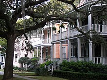
With approximate dimensions, downtown is defined as anything upon the peninsula jutting into the Beaufort River that is located east of Ribaut Road (US 21).
As the city expanded in the 20th century, additional growth focused on previously undeveloped areas north and west of the historic district.
Higginsonville is more similar in character to the Northwest Quadrant neighborhood and has its street names come from famous abolitionists during the Civil War era.
Formerly concentrated around the Beaufort rail station (the depot), the neighborhoods have similar characteristics to the Pigeon Point area and have a sizable number of military families as residents.
The Spanish Point neighborhood is located between Downtown and Mossy Oaks, generally considered to be clustered around the Technical College of the Lowcountry campus and the Beaufort Memorial Hospital.
Boundary Street and Robert Smalls Parkway have several lodging facilities and auto dealerships as prevailing business types.
Boundary Street is expected to change its appearance over the coming years due in part to a major redevelopment plan approved by the city in 2008 and supported via tax increment financing.
Uptown Beaufort refers to a series of mostly commercial properties along Boundary Street that separates the historic district from the Pigeon Point neighborhood.
Previous attempts at bringing large-scale residential development north of the air station were defeated after protests from long-time citizens and environmental advocacy groups.
Beaufort is part of the Savannah, Georgia Designated Market Area, and additionally receives Charleston television stations.
Lady's Island, the slave trade and the American Revolutionary War are the topics of an award-winning novel by the Canadian writer Lawrence Hill, The Book of Negroes (2007) (published in the US as Someone Knows My Name).
It portrays the evacuation of Black Americans from Manhattan by the British after the Revolutionary War, as they had promised freedom to those enslaved by Patriots who joined their forces.
The University of South Carolina Beaufort has a performing arts center that attracts regional and national acts[which?]
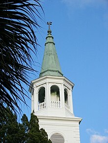
Beaufort's Jewish community dates back to the 18th century, and Beth Israel Congregation is a historic Conservative synagogue in the downtown area.
The proximity of the city to other fast-growing areas including Hilton Head Island and Bluffton as well as good access to Savannah, Georgia, the Savannah/Hilton Head International Airport, and a container port on the Savannah River make the city a desirable choice for residential and business development opportunity.
There are several areas with limited industrial uses that exist primarily in the northwestern sections of the city, close to the intersection of Boundary Street with Robert Smalls Parkway.
Due in part to its attractive location and deep connections with history and culture, the tourism and hospitality industry is also a major economic sector.
The primary attractions of these visitors include golf and beach vacations, history, water sports, and local arts and crafts.
As a result, Beaufort is home to many accommodation options ranging from upscale bed-and-breakfasts in the downtown area to standard motels and inns along Boundary Street.
An acute-care hospital and regional referral center, it is the largest medical facility between Charleston, South Carolina, and Savannah, Georgia.
In October 2007, voters approved $15 million in bonds to finance two new municipal buildings at the intersection of Boundary Street and Ribaut Road to replace aging and cramped facilities.
Recent trends have shown Beaufort to seek closer inter-governmental cooperation with neighboring jurisdictions, especially in community and regional planning.
Schoolchildren in the city attend the following public and private schools: The Beaufort Marine Corps Air Station has its own system at the elementary school level,[25] which applies to the children of Department of Defense employees who are living in the permanent base housing and children of civilians working for the United States federal government who are living in the permanent base housing.
The John Mark Verdier House at 901 Bay Street is the only home in the city open year-round to the public that is listed on the National Register of Historic Places.