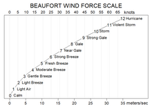
Beaufort scale
The Beaufort scale (/ˈboʊfərt/ BOH-fərt) is an empirical measure that relates wind speed to observed conditions at sea or on land.
The scale that carries Beaufort's name had a long and complex evolution from the previous work of others (including Daniel Defoe the century before).
It was first used during the 1831-1836 "Darwin voyage" of HMS Beagle under Captain Robert FitzRoy, who was later to set up the first Meteorological Office in Britain giving regular weather forecasts.
[2] The initial scale of 13 classes (zero to 12) did not reference wind speed numbers, but related qualitative wind conditions to effects on the sails of a frigate, then the main ship of the Royal Navy, from "just sufficient to give steerage" to "that which no canvas sails could withstand".
[1] In 1916, to accommodate the growth of steam power, the descriptions were changed to how the sea, not the sails, behaved and extended to land observations.
Nowadays, meteorologists typically express wind speed in kilometres or miles per hour or, for maritime and aviation purposes, knots, but Beaufort scale terminology is still sometimes used in weather forecasts for shipping[4] and the severe weather warnings given to the public.
Other warnings are issued by Met Éireann for Irish coastal waters, which are regarded as extending 30 miles out from the coastline, and the Irish Sea or part thereof: "Gale Warnings" are issued if winds of Beaufort force 8 are expected; "Strong Gale Warnings" are issued if winds of Beaufort force 9 or frequent gusts of at least 52 knots are expected.
[citation needed] This scale is also widely used in the Netherlands, Germany,[18] Greece, China, Taiwan, Hong Kong, Malta, and Macau, although with some differences between them.