Beauharnois Canal
Located in Beauharnois-Salaberry Regional County Municipality within the cities of Salaberry-de-Valleyfield, Beauharnois, Saint-Louis-de-Gonzague, and Saint-Stanislas-de-Kostka, the canal connects Lake Saint-Francis to the west (upstream) with Lake Saint-Louis to the northeast (downstream), bypassing a series of rapids on the Saint Lawrence River.
[1] The original Beauharnois Canal opened in 1843, and measured 11+1⁄4 mi (18.1 km; 9.8 nmi) in length[2] and was built on the south side of the St. Lawrence River.
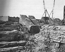
The present Beauharnois Canal was built between 1929-1932 on the south side of the St. Lawrence River, measuring 20 kilometres (12 mi)[1] or 24.5 km (15.2 mi) [3] in length, with a minimum depth of 8 metres (26 ft) and width of 182 metres (597 ft).
[1] This canal was built as part of a hydroelectric development at Beauharnois which saw a dam and power house built to take advantage of the 24 metres (79 ft) drop between Lake St. Francis and Lake St. Louis.
In the 1950s, the Beauharnois Canal had 2 locks added as part of the Saint Lawrence Seaway project, which were inaugurated in 1959.