Berlin Fortress
Frederick William I, Elector of Brandenburg ordered the engineer architect Johann Gregor Memhardt to make plans for a fortification for the town.
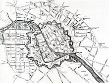
Clearly visible on the city map from 1688 is the western peninsula of Dorotheenstadt (marked with E), an urban development project of the Elector's wife, Sophie Dorothea, which is barely fortified, except on the river bank, and separated from southern wasteland only by an artificial moat.
The new ruler expanded the city again and from 1691 created a third expansion, Friedrichstadt, south of Dorotheenstadt and west of Friedrichswerder (the latter marked C and D on the map of 1688), also built outside of the fortifications.
For instance, the triangular shape of Hausvogteiplatz, a small square, corresponds to an earlier bastion of the fortifications.
The railway tracks of Berlin Stadtbahn along the eastern and northern sections of Mitte between the stations Hackescher Markt and Jannowitzbrücke are built where the fortress had been.