Bernalillo County, New Mexico
Sandia Mountain Wilderness was created in 1978 and the Petroglyph National Monument was established in June 1990.
28.50% of all households were made up of individuals, and 7.90% had someone living alone who was 65 years of age or older.
As of the 2010 United States census, there were 662,564 people, 266,000 households, and 164,104 families living in the county.
(Franklin D. Roosevelt four times, Harry S. Truman and Lyndon B. Johnson once each).
From 1992 on, the county has backed Democratic Party candidates in every presidential election.
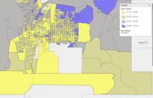
The region around Nob Hill and Downtown, which includes the University of New Mexico, is where the greatest Democratic strength in the county lies, with parts of the North Valley near the river also contributing.
The Isleta Reservation in the southern strip of the county is also a highly Democratic region.
The heavily Hispanic South Valley, as well as Atrisco and Armijo, which have long been Democratic strongholds, have been recently trending heavily toward the Republican party, with several precincts flipping in the 2024 election.
Republican strength in the county lies east of Tijeras, in parts of the southeast near Kirtland Air Force Base, and for a long time in much of the Northeast Heights region, although this area showed a Democratic trend in the 2024 election.
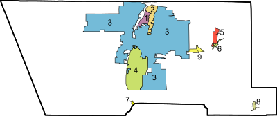
[4][20] There are three school districts in the county:[21] Bureau of Indian Education (BIE) schools: Southwestern Indian Polytechnic Institute (SIPI), a BIE community college, is in an unincorporated area in the county.
[22] Atrisco Heritage Academy HS, Kirtland Air Force Base, and National Museum of Nuclear Science & History are adjacent to but outside of the city limits.Rio Grande HS and Sandia Peak Tramway are near but not in the city limits.