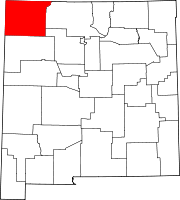
San Juan County, New Mexico
[3] San Juan County is part of the Farmington, New Mexico, Metropolitan Statistical Area.
[4] Indian reservations (and off-reservation trust lands) comprise 63.4 percent of the county's land area: The Navajo Nation takes up 60.45% and the Ute Mountain Ute Tribe Reservation another 2.93%.
The physical features include three rivers: the San Juan, Animas, and La Plata rivers; also, the Chuska Mountains and Shiprock Pinnacle to the west, volcanic structures, buttes, mesas, badlands, and fertile river valleys.
At the 2000 census there were 113,801 people, 37,711 households, and 28,924 families living in the county.
The racial makeup of the county was 52.83% White, 0.44% Black or African American, 36.88% Native American, 0.27% Asian, 0.05% Pacific Islander, 6.77% from other races, and 2.78% from two or more races.
As of the 2010 census, there were 130,044 people, 44,404 households, and 32,457 families living in the county.
[11] The racial makeup of the county was 51.6% white, 36.6% American Indian, 0.6% black or African American, 0.4% Asian, 0.1% Pacific islander, 7.3% from other races, and 3.5% from two or more races.
The only Democratic presidential candidate to win the county since 1936 was Lyndon B. Johnson in his 1964 landslide, who only narrowly won the county by just 93 votes and a margin of victory of less than 1%.


