Bernese Oberland
The numerous side valleys of the Bernese Oberland include a large number of Alpine villages, many of them being tourist resorts and connected by mountain railways to Spiez and Interlaken.
They used a number of alpine passes including; the Brünig, Susten (with a Roman mansio), Grimsel, Lötschen, Gemmi, Rawil, Sanetsch and the Col du Pillon.
After the extinction of the Zähringen line, the Bernese Oberland was ruled by a number of local Barons (including Oberhofen, Strättligen, Brienz-Ringgenberg, Wädenswil, Weissenburg).
Through conquest, purchase, mortgage or marriage politics Bern was able to acquire the majority of the Bernese Oberland from the indebted local barons between 1323 and 1400.
Under Bernese control, the five valleys enjoyed extensive rights and far-reaching autonomy in the Bäuerten (farming cooperative municipalities) and Talverbänden (rural alpine communities).
Shortly thereafter the resorts expanded into the alpine valleys (Lauterbrunnen, Grindelwald), and began attracting English guests.
However, because of the widespread poverty of the 19th century many residents of the Simmen valley and the Interlaken district emigrated to North America, Germany or Russia.
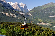
Starting in the 1930s and increasingly after 1950 funiculars, cable cars and chair lifts opened up many of the high alpine villages for winter sports and tourism.
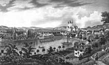
[1] The Bernese Oberland designates primarily an area around the upper valley of the Aare with its many larger and smaller side-valleys.
And its major side-valley, called the Gadmertal, on its most eastern point culminates at the Susten Pass just south of the Titlis (OW) connecting with the valley of the Alpine Reuss (UR), the northern part of the St. Gotthard Route.
The low Brünig Pass to the north connects Meiringen and the Haslital with the upper canton of Obwalden and further down to Central Switzerland and Lucerne (LU).
The easternmost section of the ridge constitutes the border with the canton of Lucerne (LU), but the western part is fully in Bernese territory.
Via the upper, southern end of the Lauterbrunnental the experienced hiker can reach the Kandertal by traversing the Tschingel and Kander Neve from northeast to southwest.
Above Spiez rises the Niesen, offering a wide view over the Bernese part of the Swiss Plateau to the northwest.
After flowing northwards, in Saanen the Saane turns to the west, firstly, in order to become La Sarine in the now French-speaking canton of Vaud (VD), and secondly, opens a railway connection to Montreux at the eastern shore of Lake Geneva.