Beit She'an
This page is subject to the extended confirmed restriction related to the Arab-Israeli conflict.Beit She'an (Hebrew: בֵּית שְׁאָן Bēṯ Šəʾānⓘ), also Beth-shean, formerly Beisan (Arabic: بيسان Bisānⓘ),[2] is a town in the Northern District of Israel.
A multi-cultural metropolis under Byzantine rule, it served as the capital of the province of Palaestina Secunda, and had a mixed population of Christians, pagans, Jews and Samaritans.
After the Arab conquest of the Levant, and following a series of devastating earthquakes (most notably in 749), the city lost its prominence, and became a medium-sized country town.
It had been entirely Muslim and Christian, designated to be part of the Jewish state in the 1947 United Nations Partition Plan for Palestine, and was captured by the Haganah in May 1948.
FitzGerald, under the auspices of the University of Pennsylvania Museum, carried out a "deep cut" on Tell el-Hisn ("castle hill"), the large tell, or mound, of Beth She'an, in order to determine the earliest occupation of the site.
His results suggest that settlement began in the Late Neolithic or Early Chalcolithic periods (sixth to fifth millennia BC.
[11] After the conquest of Beit She'an by Pharaoh Thutmose III in the 15th century BCE, as recorded in an inscription at Karnak,[12] the small town on the summit of the mound became the center of the Egyptian administration of the region.
[18] During the three hundred years of rule by the New Kingdom of Egypt, the population of Beit She'an appears to have been primarily Egyptian administrative officials and military personnel.
[20] One of those steles is particularly interesting because, according to William F. Albright,[21] it testifies to the presence of a Hebrew population: the Habiru, which Seti I protected from an Asiatic tribe.
Most are in the typical Egyptian style but some are of a "grotesque" type linked to the Aegean which caused earlier archaeologists to suggest they were of the "sea peoples" which pharaoh Ramses III claimed to have resettled in the region.
[27] Nevertheless, recent archaeomagnetic dates suggest that the first Israelite urban settlement was established either during the Solomonic period or in the pre-Omride phase of the early kingdom of Israel at the latest, and that it was probably destroyed around 935–900 BC.
[28] The Assyrian conquest of the northern kingdom of Israel under Tiglath-Pileser III (732 BC) brought about the destruction of Beit She'an by fire.
[22] The Hebrew Bible identifies Beit She'an as where the bodies of King Saul and three of his sons were hung by the Philistines after the Battle of Gilboa.
[35] One of the most interesting Roman grave finds was a bronze incense shovel with the handle in the form of an animal leg, or hoof, now in the University of Pennsylvania Museum.
[40] Scythopolis was primarily Christian, as attested to by many churches, but evidence of Jewish habitation and a Samaritan synagogue indicate established communities of these minorities.
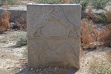
Many colourful mosaics were preserved, such as that featuring the zodiac in the Lady Mary's Monastery, or the one with a temple menorah and the phrase shalom in the House of Leontius synagogue.
In common with state-directed building work carried out in other towns and cities in the region during the 720s,[46] Baysan's commercial infrastructure was refurbished: its main colonnaded market street, once thought to date to the sixth century, is now known—based on a mosaic inscription—to be a redesign dating from the time of the Umayyad caliph Hisham ibn Abd al-Malik (r.
[48] Jerusalemite historian al-Muqaddasi visited Baysan in 985, during the Abbasid Caliphate and wrote that it was "on the river, with plentiful palm trees, and water, though somewhat heavy (brackish.)"
[51] A small Crusader fortress surrounded by a moat was built in the area southeast of the Roman theatre, where the diminished town had relocated after the 749 earthquake.
[2] The Swiss–German traveler Johann Ludwig Burckhardt described Beisan in 1812: "The present village of Bysan contains seventy or eighty houses; its inhabitants are in a miserable condition, from being exposed to the depredations of the Bedouins of the Ghor, to whom they also pay a heavy tribute.
[57] In the early 20th century, though still a tiny and obscure village, Beisan was known for its plentiful water supply, fertile soil, and producing olives, grapes, figs, almonds, apricots, and apples.
According to a census conducted in 1922 by the British Mandate authorities, Beit She'an (Baisan) had a population of 1,941, consisting of 1,687 Muslims, 41 Jews and 213 Christians.
He further noted that "many nomad and Bedouin encampments, distinguished by their black tents, were scattered about the riverine plain, their flocks and herds grazing round them.
[55][59][60] In 1938, after learning of the murder of his close friend and Jewish leader Haim Sturmann, Orde Wingate led his men on an offensive in the Arab section of Baysan, the rebels’ suspected base.
[65] Joseph Weitz, a leading Yishuv figure, wrote in his diary on May 4, 1948, that, "The Beit Shean Valley is the gate for our state in the Galilee...[I]ts clearing is the need of the hour.
After Israel's Declaration of Independence in May 1948, during intense shelling by Syrian border units, followed by the recapture of the valley by the Haganah, the Arab inhabitants fled across the Jordan River.
[citation needed] Historian Saleh Abdel Jawad writes that Beisan experienced a massacre via aerial bombardment by Israeli forces that was "entirely without military justification" and which was used as "a tool of expulsion".
[69] In the 1974 Beit She'an attack, militants of the Popular Democratic Front for the Liberation of Palestine, took over an apartment building and murdered a family of four.
[55] When the ancient city of Beit She'an was opened to the public in the 1990s and turned into a national park, tourism became a major sector of the economy.
The local football club, Hapoel Beit She'an spent several seasons in the top division in the 1990s, but folded in 2006 after several relegations.