Bilbao (Mesoamerican site)
Bilbao is a Mesoamerican archaeological site about 1 mile (1.6 km) from the modern town of Santa Lucía Cotzumalguapa in the Escuintla department of Guatemala.
[2] The site lies among sugar plantations on the Pacific coastal plain and its principal phase of occupation is dated to the Classic Period.
[3] Bilbao was a major centre belonging to the Cotzumalhuapa culture with its main occupation dating to the Late Classic (c. AD 600–800).
[5] Bilbao lies of the outskirts of Santa Lucía Cotzumalguapa, situated approximately 370 metres (1,210 ft) above mean sea level.
The urban growth of modern Santa Lucía Cotzumalguapa has expanded to the edge of the monumental architecture of the site.
[7] The dominant geographical feature close to the Cotzumalhaupa Nuclear Zone is the Volcán de Fuego, one of the most active volcanoes in the world, its crater rising to an altitude of 3,835 metres (12,582 ft) above mean sea level at only a distance of about 21 kilometres (13 mi) from Bilbao itself.
The activity of the volcano must have impacted upon the population of the site, which must regularly have suffered from falls of volcanic ash, affecting agriculture, transport routes and perishable dwellings.
[7] The land containing the archaeological remains was cleared in 1860 by Pedro de Anda, a local civic official, to establish a coffee plantation by the name of Finca Peor es Nada.
[9] Austrian physician Simeon Habel drew some of the sculptures at Bilbao in 1863, his drawings were published by the Smithsonian Institution in 1878.
Adolph Bastian of the Royal Museum in Berlin visited the site in 1876 and entered into a contract with Pedro de Anda to explore the remains.
[5] The sculptural style of the site differs from that of the Classic Maya and may represent the vanguard of the Nahua-speaking Pipil who migrated from central Mexico and settled the Pacific coastal plain of Guatemala and El Salvador in the Postclassic Period.
[12] The Mexican influence evident at Bilbao may not have arrived directly but could instead have been transmitted via a neighbouring polity such as groups from the Tiquisate or La Gomera areas of the Guatemalan Pacific coastal region.
Parsons has suggested that Bilbao was a colony founded during the Middle Classic (c. 400–550) by the distant metropolis of Teotihuacan in the Valley of Mexico, with El Tajín as an intermediary, and that it became independent between AD 550 and 700.
[16] Bilbao's architecture is buried under a thick layer of volcanic soil to an extent that only the largest structures can be distinguished as mounds.
[24] Ballgame reliefs at Bilbao feature blossoming and fruiting plants symbolic of agricultural fertility.
These are boulders carved to represent obese human figures and are found at many sites along the Pacific coast.
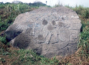
[30] Monument 3 depicts a larger ballplayer figure and a smaller death god, both of whom are wearing ballgame yokes, standing in front of a temple.
[33] Monument 19 depicts three figures, the principal individual wears an elaborate headdress with a Xiuhcoatl ("turquoise/fire serpent") plume.
When it was excavated by Parsons it was found lying on its side with its head resting upon the lowest step of a stairway with Monument 59 (a throne or altar) upside down on top of it.
[38] Golón is an important area within the Cotzumalhuapa Nuclear Zone, located 1 kilometre (0.62 mi) from Bilbao and connected to the same system of paved causeways.