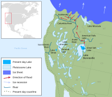
Lake Bonneville
Lake Bonneville was the largest Late Pleistocene paleolake in the Great Basin of western North America.
It was a pluvial lake that formed in response to an increase in precipitation and a decrease in evaporation as a result of cooler temperatures.
[1] These shorelines appear as shelves or benches that protrude from the mountainside above the valley floor, are visible on the ground from long distances and on satellite images, and have both depositional and erosional segments along their lengths.
[5] For most of its existence (that is, during the transgressive plus regressive phases) Lake Bonneville had no river outlet and occupied a hydrographically closed basin.
[10] While Lake Bonneville existed the patterns of wave- and current-forming winds were not significantly affected by the Laurentide and Cordilleran ice sheets in northern North America.
[14] G.K. Gilbert was one of the greatest geologists of the 19th Century, and his monumental work on Lake Bonneville, published in 1890, set the stage for scientific research on the paleolake that continues today.
"[16] Although a general description and understanding of Lake Bonneville has been established by the work of many people, details of the paleolake, including its history and connections to global environmental systems, will be pursued for many years to come.
[1][20] Groundwater sapping on the north slope of the Marsh Creek alluvial fan, which began long before the lake had reached its highest level, added to the instability and ultimate collapse of the fan-dam.
[20] Downcutting during the flood through the Marsh Creek alluvial-fan deposits and into the underlying Neogene sand, mud, and landslide debris,[21] caused lake level to drop about 410 ft (125 m).
[27] The Bonneville marl at locations far from sources of clastic sediment (gravel, sand, and silt), such as river deltas or active wave zones, is dominated by clay-sized particles of calcium carbonate that precipitated chemically from the lake water.
[29][30] Dropstones, probably mostly derived from shore ice, but possibly also from floating root balls, are common in the marl, and consist of granule- to boulder-sized clasts.
The contact at the top of the flood bed is transitional to massive marl that was deposited on the lake floor during Provo time.
[27] The flood bed is best developed and most obvious in straits between partially submerged mountain ranges or in places where bottom currents were strong as lake water flowed toward its outlet at Red Rock Pass.
[2][31] In addition to the abundant geological features produced by Lake Bonneville, such as shorelines and sediments, fossilized fish bones and scales reveal information about the physical and chemical characteristics of the paleolake.

![Chronology of Lake Bonneville. “Calibrated ages” are approximate calendar years before present (present regarded as A.D. 1950). Elevations are adjusted for differential isostatic rebound in the basin.[3]](http://upload.wikimedia.org/wikipedia/commons/thumb/a/a6/Chronology_figure.png/220px-Chronology_figure.png)
