Last Glacial Maximum
[6][7] Glacier fluctuations around the Strait of Magellan suggest the peak in glacial surface area was constrained to between 25,200 and 23,100 years ago.
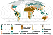
[12][13][14] According to the United States Geological Survey (USGS), permanent summer ice covered about 8% of Earth's surface and 25% of the land area during the last glacial maximum.
Hence, despite having temperatures similar to those of glaciated areas in North America and Europe, East Asia remained unglaciated except at higher elevations.
These anticyclones generated air masses that were so dry on reaching Siberia and Manchuria that precipitation sufficient for the formation of glaciers could never occur (except in Kamchatka where these westerly winds lifted moisture from the Sea of Japan).
The relative warmth of the Pacific Ocean due to the shutting down of the Oyashio Current and the presence of large east–west mountain ranges were secondary factors that prevented the development of continental glaciation in Asia.
Even in less affected regions, rainforest cover was greatly diminished, especially in West Africa where a few refugia were surrounded by tropical grasslands.
In Australia, shifting sand dunes covered half the continent, while the Chaco and Pampas in South America became similarly dry.
[18] However, it is estimated that during the LGM, low-to-mid latitude land surfaces at low elevation cooled on average by 5.8 °C relative to their present-day temperatures, based on an analysis of noble gases dissolved in groundwater rather than examinations of species abundances that have been used in the past.
[20] The massive sheets of ice locked away water, lowering the sea level, exposing continental shelves, joining land masses together, and creating extensive coastal plains.
[25] In Africa and the Middle East, many smaller mountain glaciers formed, and the Sahara and other sandy deserts were greatly expanded in extent.
[21] The Atlantic deep sea sediment core V22-196, extracted off the coast of Senegal, shows a major southward expansion of the Sahara.
[28] In the Hex River Mountains, in the Western Cape, block streams and terraces found near the summit of Matroosberg evidences past periglacial activity which likely occurred during the LGM.
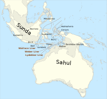
[43] Between Sahul and Sundaland – a peninsula of South East Asia that comprised present-day Malaysia and western and northern Indonesia – there remained an archipelago of islands known as Wallacea.
[51] Central Europe had isolated pockets of relative warmth corresponding to hydrothermally active areas, which served as refugia for taxa not adapted to extremely cold climates.
[52] In the Cantabrian Mountains of the northwestern corner of the Iberian Peninsula, which in the present day have no permanent glaciers, the LGM led to a local glacial recession as a result of increased aridity caused by the growth of other ice sheets farther to the east and north, which drastically limited annual snowfall over the mountains of northwestern Spain.
The Cantabrian alpine glaciers had previously expanded between approximately 60,000 and 40,000 years ago during a local glacial maximum in the region.
[53] In northeastern Italy, in the region around Lake Fimon, Artemisia-dominated semideserts, steppes, and meadow-steppes replaced open boreal forests at the start of the LGM, specifically during Heinrich Stadial 3.
[62] Sediment core analysis from Lone Spruce Pond in southwestern Alaska show it was a pocket of relative warmth.
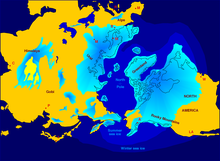
[63] Following a preceding period of relative retreat from 52,000 to 40,000 years ago,[64] the Laurentide Ice Sheet grew rapidly at the onset of the LGM until it covered essentially all of Canada east of the Rocky Mountains and extended roughly to the Missouri and Ohio Rivers, and eastward to Manhattan,[65][66][67] reaching a total maximum volume of around 26.5 to 37 million cubic kilometres.
Glaciers forced the early human populations who had originally migrated from northeast Siberia into refugia, reshaping their genetic variation by mutation and drift.
On the western side of the Andes the ice sheet reached sea level as far north as in the 41 degrees south at Chacao Channel.
[citation needed] The western coast of Patagonia was largely glaciated, but some authors have pointed out the possible existence of ice-free refugia for some plant species.
During the coldest period of the Last Glacial Maximum vegetation at this location was dominated by Alpine herbs in wide open surfaces.
[77] Within this parkland vegetation Magellanic moorland alternated with Nothofagus forest, and as warming progressed even warm-climate trees began to grow in the area.
It is estimated that the tree line was depressed about 1,000 m relative to present day elevations during the coldest period, but it rose gradually until 19,300 years ago.
[83] δD values from plant waxes from the LGM are significantly more enriched than those in the present and those dating back to MIS 3, evidencing this increased aridity.
Though coccolith size increases in Calcidiscus leptoporus suggest stronger trade winds during the LGM caused there to be increased coastal upwelling of the northwestern coast of Africa,[89] planktonic foraminiferal δ13C records show upwelling and primary productivity were not enhanced during the LGM except in transient intervals around 23,200 and 22,300 BP.
The increased sinking particle flux removed neodymium from shallow waters, producing an isotopic ratio change.
[91] On the Island of Hawaii, geologists have long recognized deposits formed by glaciers on Mauna Kea during recent ice ages.
[93] Abyssal Pacific overturning was weaker during the LGM than in the present day, although it was temporarily stronger during some intervals of ice sheet retreat.