Boonah, Queensland
Download coordinates as: Boonah is a rural town and locality in the Scenic Rim Region, Queensland, Australia.
Frog Buttress is a popular rock climbing cliff on the north-west side of Mount French.
The Wyaralong Dam was constructed east of Boonah on Teviot Brook, a tributary of the Logan River.
[4] Water for the town is supplied from Lake Moogerah on Reynold's Creek, a tributary of the Bremer River.
Maroon Dam is another reservoir built 25 kilometres (16 mi) south of Boonah at the base of the McPherson Range.
[8] In its early years the area was stocked with sheep but the region was discovered to be well suited for cattle and over time became renowned for the quality of its beef and dairy herds.
[9] In January 1861, a massacre of Ugarapul people, estimated to be as many as 40, is recorded in the area of Hardie's Station, Dugandan Scrub.
Frederick Bowman took advantage of the suitability of the area for cattle and is considered one of the dairying pioneers of the region.
Following the introduction of the Crown Lands Alienation Act of 1868 and the subdivision of the large pastoral runs, the settlement fell within the boundaries of a new 320 acre property acquired by John Hooper in 1878.
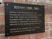
[9] Blumbergville took its name from a store owned by three brothers, Max, Levi and Adolf Blumberg, located on the later site of the Commercial Hotel in High Street, Boonah.
[24] Thomas Hardcastle donated 1 acre (0.40 ha) of land for a church on Old Mount Alford Road near the former Dugandan Bridge.
[28] In 1892 concerns about flooding led to fundraising to relocate the church to the southern end of High Street in Boonah (now the location of the manse).[when?
[33] In 1887, the railway line from Ipswich was extended to the area,[34] with the name Boonah given to a rail siding at Blumbergville[7] located one stop before the terminus at the settlement of nearby Dugandan.
[9] Following devastating floods in 1887,[12] the main commercial interests for the district relocated from the lower lying Dugandan, near the railway terminus, to the higher ground of Boonah.
(the diocesan architect for the Anglican Diocese of Brisbane) and built by Mr Vincent of Boonah.
[43] The Boonah Butter Factory closed on 1 March 1974 due to declining production as a result of low prices for milk and shifting agricultural practices in the region.
[44][45] Miss Esme Clarke's Private School opened on 1905 in a room was rented from All Saints Church.
It was operated by the Sisters of Mercy until 1989 when it passed to the lay leadership of principal Kathleen Lambourne.
[1] Boonah has a number of heritage-listed sites, including: The area produces vegetables for the nearby Brisbane Markets notably carrots, potatoes, and cereal crops.
In the 2000–01 financial year the Shire of Boonah produced $67 million worth of agricultural products.
[56] Nearly two-thirds of the recorded food and fibre businesses in the Boonah area produced beef cattle.
[57][63] The Bremer Institute of TAFE had a campus at Boonah, which operated at limited functionality for several years due to cutbacks.
[69]The Blumberville Clock on the footpath in High Street outside the Scenic Rim Regional Council offices (27°59′49″S 152°40′57″E / 27.9969°S 152.6824°E / -27.9969; 152.6824 (Blumbergville Clock)) was created as a sculptural steampunk timepiece by local artist Christopher Trotter in collaboration with local clockmaker David Bland.
It was commissioned by the Scenic Rim Regional Council in 2014 to honour the spirit of resilience of the community following the 2011 and 2013 floods.
[74] Boonah experiences sub-tropical climatic conditions typically with warm wet summers and mild dry winters.