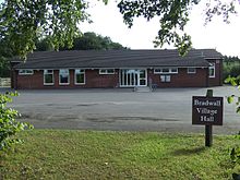
Bradwall
The village is not mentioned in the 11th-century Domesday survey, but from the 13th century gained notability as the manorial estate of Richard de Bradwall and his successors, including the families of Venables, Berington and Oldfield.
Bradwall is not mentioned in the Domesday Book, completed in 1086 for William I of England, at which time the area was thought to be uncultivated moorland between Brereton and Warmingham, that formed part of the southern boundary of the Barony of Kinderton, the historic name of Middlewich.
[3][4] Variant spellings include (dates in brackets):[5] Brade-,[6] -wal, -wale, -walle, Bradwall (1226),[7] Brad(e)well(e) (1281),[8] Brod(e)wall (1324),[9][Note 1][10] Beatwall (1326),[11] Broadwall (1415),[12] Bardwell (1438),[12] and, Bradwell (1724).
A Late Bronze Age axe head dating to around 1000-801 BC was found near Fields Farm Fisheries in Bradwall.
[14] Around a thousand Roman coins dating from not earlier than 270 AD were discovered in 1820, on the eastern side of Bradwall, a short distance from the Brindley Moor's Farm and about four miles direct from the Roman station at Kinderton, at a point where a small brook is crossed by the footpath from Brereton to Sandbach.
[15][16] Discovered by a mole-catcher, the coins included examples of denarii of Gallienus, Claudius II, Tetricus, Victorinus, and Diocletian.
[17] The remains of part of a Roman road, are also thought to have been discovered near the western side of Bradwall, by Boothlane, towards the west of Sandbach, and near King Street.
Several families have been associated with either the Manor, or the more recent country seat at Bradwall Hall, including: The country seat of Bradwall (i.e. its buildings and its estate) is thought to have been originally on the west side of the parish, within a rectangular moat with a large pool,[29] with the name Hallfields, near Hollins Wood.
Recorded as early as 1803,[32] the Hall is described as "a large white house with no architectural features of interest, is said by Dr. George Ormerod to have been 'a large building of brick, finished with gables, at the end of an avenue of firs and evergreens,' which had been enlarged and modernised from time to time".
[37] They were charged with manslaughter, and sentenced by the judge Sir Charles Crompton to be sent to the Reformatory at Bradwall, which "was to rank as the most enlightened and successful institution of its kind in the country".
He was in and out of reform school until the age of 16, but as a persistent offender, served sentences in Knutsford and Dartmoor prisons.
The 1881 Census notes that nearly 20% of the residents were in agriculture followed by nearly 12% in domestic service; 43% had an unknown, or non-specific occupation (see table below).
[44] The 1902 Kelly's Directory of Cheshire, noted that in Bradwall, "the crops are oats, roots, wheat and rye.
The land is chiefly pasture", and that commercially, there are a total of 15 farmers, one blacksmith and the superintendent of the Reformatory School.
[61] The thickness of the bedrock is estimated at around 400 m, and was formed around 221 to 227 million years ago in the Late Triassic Carnian period, in a hot dry environment.
[63] A small pocket of undifferentiated river terrace deposits of sand and gravel,[64] dating from the Quaternary about 2.5 million years old, is located southeast of the intersection of Pillar Box Lane with Bradwall Road.
[Note 7] Several boreholes in the area reveal glacial sand and clays with a couple of layers of ground water.
About five other minor seismic profiles also pass through Bradwall, all managed by the UK Onshore Geophysical Library, that are uses by resources exploration companies (such as oil, gas and coal).
[69] According to the 2011 census, the population of Bradwall Civil Parish totals 182 people (93 men and 89 women)[71] in 67 households.
[93] Although it has a Sandbach postcode, coarse fishing is available in the southeast of Bradwall Civil Parish at Field Farm Fisheries with five pools stocked with barbel, bream, carp, chub, crucian, rudd, roach and tench.
[100] The Quinta Arboretum, created by Sir Bernard Lovell, is 9 mi (14 km) away in Swettenham, and features multiple species of trees, shrubs and avenues.
[105] About 4 mi (6.4 km) away is the Bagmere reserve, a Site of Special Scientific Interest,[106] due to its internationally important series of meres and mosses, and "the last remaining site in Cheshire for the small pearl-bordered fritillary butterfly"[107] The nearest bird reserve is 26 mi (42 km) way at Coombes Valley.
[110] A 1.5 mi (2.4 km) stretch of the M6 motorway passes through the east of the parish,[48] which is a couple of miles from the M6 Exit 17.
[48] National Cycle Way Route 71 Parkgate to Teggs Nose, Macclesfield, passes about 100 m (330 ft) from the northeast boundary of Bradwall.
Closing to passengers in 1960, a single freight line between Sandbach via Middlewich railway station and Northwich also just enters Bradwall in the northwest, near the electricity substation in Moston.
[136] Built in 1882,[137] Bradwall's only place of worship is the Wesleyan Chapel Methodist Church on Ward's Lane.
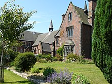
[140] St Mary's Church in Sandbach has a chancel that belonged to Bradwall Hall,[141] and includes the arms of Oldfield.
[146] Public utilities to Bradwall Parish County are served by Scottish Power Manweb regional electricity company,[147] the North West gas network[148] (a gas pipeline passes through Bradwall along the route of the M6 motorway,[149]) and water is provided by Severn Trent Water.
FreeView digital TV is transmitted from the Winter Hill transmitter 33.5 mi (53.9 km) away, and is part of the Granada television region.


