Brahmaputra River
It originates in the Manasarovar Lake region, near Mount Kailash, on the northern side of the Himalayas in Burang County of Tibet where it is known as the Yarlung Tsangpo River.
[3] The Brahmaputra flows along southern Tibet to break through the Himalayas in great gorges (including the Yarlung Tsangpo Grand Canyon) and into Arunachal Pradesh.
[14] The upper reaches of the Brahmaputra River, known as the Yarlung Tsangpo from the Tibetan language, originates on the Angsi Glacier, near Mount Kailash, located on the northern side of the Himalayas in Burang County of Tibet.
The source of the river was earlier thought to be on the Chemayungdung glacier, which covers the slopes of the Himalayas about 60 mi (97 km) southeast of Lake Manasarovar in southwestern Tibet.
After passing Pi (Pe) in Tibet, the river turns suddenly to the north and northeast and cuts a course through a succession of great narrow gorges between the mountainous massifs of Gyala Peri and Namcha Barwa in a series of rapids and cascades.
The Yarlung Tsangpo leaves the part of Tibet to enter Indian state of Arunachal Pradesh, where the river is called Siang.
The reason for such an unusual course and drastic change is that the river is antecedent to the Himalayas, meaning that it had existed before them and has entrenched itself since they started rising.
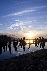
[15] At Guwahati, near the ancient pilgrimage centre of Hajo, the Brahmaputra cuts through the rocks of the Shillong Plateau, and is at its narrowest at 1 km (1,100 yd) bank-to-bank.
The terrain of this area made it logistically ideal for the Battle of Saraighat, the military confrontation between the Mughal Empire and the Ahom Kingdom in March 1671.
(South of Gaibanda, the Old Brahmaputra leaves the left bank of the mainstream and flows past Jamalpur and Mymensingh to join the Meghna River at Bhairab Bazar.)
[16] The Jamuna joins with the Ganga north of Goalundo Ghat, below which, as the Padma, their combined waters flow to the southeast for a distance of about 120 km (75 mi).
In an 8.8 magnitude earthquake on 2 April 1762, however, the main channel of the Brahmaputra at Bhahadurabad point was switched southwards and opened as Jamuna due to the result of tectonic uplift of the Madhupur tract.
The thickness of the sediment accumulated above the Precambrian basement has increased over the years from a few hundred meters to over 18 km (11 mi) in the Bengal fore-deep to the south.
The ongoing subsidence of the Bengal Basin and the high rate of Himalayan uplift continues to contribute to the large water and sediment discharges of fine sand and silt, with 1% clay, in the Brahmaputra River.
The river flow is strongly influenced by snow and ice melting of the glaciers, which are located mainly on the eastern Himalaya regions in the upstream parts of the basin.
Deforestation in the Brahmaputra watershed has resulted in increased siltation levels, flash floods, and soil erosion in critical downstream habitat, such as the Kaziranga National Park in middle Assam.
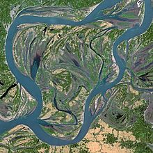
The course of the Brahmaputra River has changed dramatically over the past 250 years, with evidence of large-scale avulsion, in the period 1776–1850, of 80 km (50 mi) from east of the Madhupur tract to the west of it.
Constructed at a narrow braid belt of the river, it is 4.8 km (3.0 mi) long with a platform 18.5 m (61 ft) wide, and it is used to carry railroad traffic as well as gas, power and telecommunication lines.
One idea about the most recent avulsion is that the change in the course of the main waters of the Brahmaputra took place suddenly in 1787, the year of the heavy flooding of the river Tista.
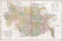
In the middle of the 18th century, at least three fair-sized streams flowed between the Rajshahi and Dhaka Divisions, viz., the Daokoba, a branch of the Tista, the Monash or Konai, and the Salangi.
In Renault's time, the Brahmaputra as a first step towards securing a more direct course to the sea by leaving the Mahdupur Jungle to the east began to send a considerable volume of water down the Jinai or Jabuna from Jamalpur into the Monash and Salangi.
These rivers gradually coalesced and kept shifting to the west till they met the Daokoba, which was showing an equally rapid tendency to cut towards the east.
In Renault's Altas they very much resemble the rivers of Jessore, which dried up after the hundred-mouthed Ganga had cut her new channel to join the Meghna at the south of the Munshiganj subdivision.
In 1809, Francis Buchanan-Hamilton wrote that the new channel between Bhawanipur and Dewanranj "was scarcely inferior to the mighty river, and threatens to sweep away the intermediate country".
In the 1990s and 2000s, there was repeated speculation that mentioned Chinese plans to build a dam at the Great Bend, with a view to diverting the waters to the north of the country.
[31] At the Kathmandu Workshop of Strategic Foresight Group in August 2009 on Water Security in the Himalayan Region, which brought together in a rare development leading hydrologists from the basin countries, the Chinese scientists argued that it was not feasible for China to undertake such a diversion.
[33] This claim has also been reiterated by the Government of India, in an attempt to assuage domestic criticism of Chinese dam construction on the river, but is one that remains hotly debated.
These people rely on the annual 'normal' flood to bring moisture and fresh sediments to the floodplain soils, hence providing the necessities for agricultural and marine farming.
Brahmaputra and Ganges floodwaters can be supplied to most lands in India by constructing a coastal reservoir to store water on the Bay of Bengal sea area.
These are as follows as per Google Map Satellite View:- National Waterway 2 (NW2) is 891 km long Sadiya-Dhubri stretch of Brahmaputra River in Assam.