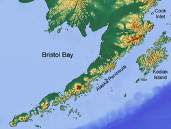
Bristol Bay
Bristol Bay (Central Yupik: Iilgayaq, Russian: Залив Бристольский[1]) is the easternmost arm of the Bering Sea, at 57° to 59° North 157° to 162° West in Southwest Alaska.
A number of rivers flow into the bay, including the Cinder, Egegik, Igushik, Kvichak, Meshik, Nushagak, Naknek, Togiak, and Ugashik.
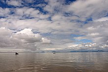
Coupled with the extreme number of shoals, sandbars, and shallows, it makes navigation troublesome, especially during the area's frequently strong winds.
After establishing some temporary settlements in the late 1790s, The Russian American Company sent exploratory parties to document the coast and nearby inland areas of Bristol Bay.
Additionally, ships of the Russian Navy conducted extensive surveys of the Bering Sea coastline into the mid-19th century, naming many of the geographical features commonly used today: Capes Constantine, Chichagof, Menshikof and Greig, Mounts Veniaminof and Pavlof, Becharof Lake, etc.
Fishing activity peaks for specific species during times of the highest concentration of salmon moving from the saltwater Pacific Ocean to the brackish Bristol Bay, then finally to their freshwater natal spawning streams at the headwaters of the many lakes and rivers in the Bristol Bay watershed.
The number of business lodges, hunting- and fishing-resorts and visitors to the nearby Katmai National Park and Preserve has grown exponentially in recent years.
The draft plan by the Bureau of Land Management (pending public comments until 2/5/2007), also proposes to open most of the BLM's 3,600,000 acres (1,500,000 ha) in the area to hard rock mining and oil and gas drilling.
A mineral exploration project investigating a large porphyry copper, gold, and molybdenum deposit in the Bristol Bay region has been proposed and may be undertaken by British-Australian[9] Rio Tinto Group and Japanese [10] conglomerate Mitsubishi.
Northern Dynasty Minerals LLC staked a claim on the site in 2001 and with its partners, invested 500 million dollars into the project.
Because of the estimated 10 billion tons of mining waste that must be permanently stored in the area, which is an active earthquake zone, and Rio Tinto's environmental track record, which is seen as poor by many environmental advocacy groups, fears have been raised about the potential impact on the Bristol Bay area and its wildlife and residents.
In April 2003, the U.S. Environmental Protection Agency issued an assessment of the impact of the proposed mining operations on fisheries, wildlife, and native Alaska tribes.
[12] In July 2019, the EPA withdrew their preemptive proposed determination to restrict use of the pebble deposit area as a disposal site.
[14][15] After more than two decades of opposition by a majority of Bristol Bay residents and Tribes, the Environmental Protection Agency (EPA) used its authority under the Clean Water Act 404(c) to stop the proposed Pebble Mine project.
The EPA released a Final Determination which declared that after extensive scientific and technical research and robust stakeholder engagement that the Pebble Mine would have unacceptable adverse affects to salmon fishery areas in the Bristol Bay watershed.