Bryndwr
He farmed this area after being given 100 acres (40 ha) freehold by his father-in-law Thomas Parr in 1851, who was granted Rural Section 188 from the Canterbury Association.
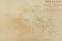
Jeffreys subdivided the land, selling 180 lots at auction as the "valuable suburb of Bryndwr", in 1880.
Jeffreys, his wife and daughter returned to Glandyfi castle after his elder brother, Edward, died in 1888.
In about 1957, the Roper's Foodmarket in this group of shops was designed by local architect Paul Pascoe.
[14] Land was further subdivided during the 1940s, 1950s and 1960s, and these streets were laid out in the sinuous nested form of the Radburn design.
[15] Street names from this period of subdivision included notable politicians (Attlee, Truman, Evatt, Eden), Otago landmarks (Earnslaw, Hollyford, Hooker, Aorangi, Lyall, Sealy), names associated with Christ's College, (Blanch, Bourne, Condell, Hudson, Flower, Harris, Merton, Moreland, Richards, Tothill), and HMS Bounty, (Bounty, Resolution, Pitcairn, Christian).
The remainder of Bryndwr is similar in socio-economic status to the adjacent suburbs of Merivale, Fendalton, Burnside and Papanui, but this pocket contrasts in particular with the neighbouring suburbs of Fendalton to the south and Merivale to the East, which are two of the highest socio-economic areas.
As an older suburb, Bryndwr has well established cultural, sporting and commercial facilities, including a Council Service Centre, several schools and parks, and two supermarkets.
[34] There are several privately owned rental developments in Bryndwr available to residents 60 years old and over, as well as: Waterways that begin in or pass through the suburb are tributaries to the Avon River.