Cadell Fault
The Cadell Fault is notable due to that impact and has been described as one of the most significant examples of seismic activity changing the course of rivers.
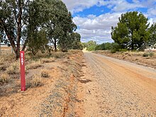
[1] The fault is visible as a continuous earthen ridge along the Cobb Highway between Deniliquin and Echuca, and extends further south into Victoria.
[3] The uplift effectively dammed the river and formed a large expanse of water, continuously fed by glacial and snow melt in the Snowy Mountains.
After a time, the flow found its present course into the Edward River and began to make its way westward via the Deniliquin region.
[6] The Narrows were noted by early squatters in the area to be somewhat unusual given its straight sides, compared to the more sloping bank formation of mature rivers[7] The damming of the Murray by the Cadell Fault directly led to the creation of the Barmah Red Gum Forests, now protected by the Barmah National Park in Victoria and Murray Valley National Park in New South Wales.
The damming caused the creation of an alluvial fan (through aggradation)[3] on which the red gum forests established, and the ongoing flooding and draining of the area has led to the arboreal ecosystem present today.
Wind-blown, or aeolian, movement of surface soils created the Barmah Sandhills on the north-eastern edge of the lake.
Eventually, erosive water flows drained the prehistoric Lake Kanyapella along the course of the current Murray River.
Based on modelling of the maximum credible earthquake, of moment magnitude scale (MMS) 7.2, the damage incurred would be catastrophic, with over 1,000 square kilometres of land suffering 50% loss of structures.