California State Route 67
It begins at Interstate 8 (I-8) in El Cajon and continues to Lakeside as the San Vicente Freeway before becoming an undivided highway through the eastern part of Poway.
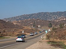
[2][3] The freeway ends, and SR 67 turns north and becomes an undivided highway at Mapleview Street, crossing the San Diego River and entering the locale of Moreno.
SR 67 then enters the rural area east of Sycamore Canyon County Open Space Preserve near the locale of Foster, passing to the west of San Vicente Reservoir.
In eastern Poway, SR 67 veers east, eventually leaving the city and entering unincorporated Rock Haven.
"[10] On October 21, 1885, the county Board of Supervisors agreed to a realignment of the Julian road, in what was known as the Bernardo District, onto private property.
[11] The road was described in 1890 by The San Diego Union and Daily Bee as passing through farms, and the grade was "cut on the west side of the canyon and buttressed with granite the greater part of the way."
[21] In 1925, there were 12 miles (19 km) left of unpaved road between Ramona and Julian, and state and county taxes were to be used to fund this project.
[25] The road that would become SR 67 was added to the state highway system in 1933, from El Cajon to near Santa Ysabel,[26] and was designated as Route 198 in 1935.
[35] The State Highway Commission decided to reroute SR 67 through Lakeside in 1954, moving it closer to the San Diego River and away from the city center, using the land formerly occupied by the old railroad.
[39] By December 1968, the freeway was complete from I-8 north to Woodside Avenue; the grade at the northern end was smoothed out during the widening of the road in early 1970.
At this time, County Supervisor Dianne Jacob proposed expanding the highway portion to four lanes along the entire route.
[49] Following a safety initiative, including the involvement of law enforcement and trucking companies, accidents and fatalities both decreased by the end of 2001.
[50] Accidents continued, however, and by November 2008, electronic signs were installed to inform motorists of their speed, and another publicity campaign had been launched.
[53] In May 2009, the San Diego Association of Governments (SANDAG) announced that fixing SR 67 was number 17 on its priority list, resulting in an estimated 2030 completion of a four-lane highway that would not be limited-access.
[55] Signs were installed in 2010 to encourage drivers to practice safe driving habits; from January 2007 to early December 2010, twenty-four people died from accidents on SR 67.
[56] Following a March 2009 fatal crash, some of the survivors filed a lawsuit against Caltrans for negligence in maintaining and designing the highway, but the suit was decided in favor of the department.
[57] In a 2010 report, Caltrans suggested that two lanes could be added along the highway from I-8 to Dye Road in order to improve traffic flow.
[66] That year, there were plans to widen Route 67 from Mapleview Street to Dye Road; however, when threatened with a lawsuit from Save Our Forests and Ranchlands, SANDAG agreed to "reconsider" the project.
[73] Except where prefixed with a letter, postmiles were measured on the road as it was in 1964, based on the alignment that existed at the time, and do not necessarily reflect current mileage.