California State Route 88
[5] The highway is occasionally used as a detour when U.S. Route 50, which follows the South Fork American River to ascend the Sierra Nevada, is flooded or otherwise closed.
The two routes separate to pass along opposite sides of the Camanche Reservoir, where SR 88 enters Amador County.
As the road enters Amador County, the route begins an ascent up the foothills of the Sierra Nevada towards Jackson.
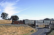
[5] Between Sunnybrook and Martell, the road runs adjacent the corridor of the Amador Central Railroad, an abandoned freight rail line, purchased and operated by the Amador County Historical Society and other heritage railway enthusiasts who sponsor occasional train rides along the route.
[9][10] The route enters Jackson, the largest town traversed in the Sierra foothills by the highway.
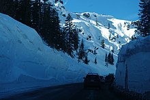
[14] To scale the western slope of the Sierra Nevada, East of Pine Grove Highway 88 follows a ridge that separates the watershed of the North Fork Mokelumne River to the south of the highway, with a number of other watersheds to the north.
At the highest elevations the watershed to the north of the road and the ridge is the Silver Fork American River.
Several overlooks are located at spots where SR 88 follows this ridge which provide views into the canyons of each of these rivers.
For several miles this ridge, and by extension SR 88, form the boundary between Amador and El Dorado County.
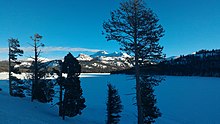
[16] Just past Silver Lake, Route 88 reaches a geographic feature known as the Carson Spur.
The two routes run concurrent through Woodfords Canyon of the Carson River, which provides the final descent out of the Sierra Nevada.
[5] Hope Valley, Woodsfords Canyon and Markleeville are often cited as one of the best areas for autumn foliage viewing in the state of California.
Improvements expected to be completed soon included paving a road to be used for the highway west of Martell towards what is today SR 124 and re-alignments along parts of the ridge, including bypassing a mountain in the ridge area called Peddler's Hill.
[36] As the SR 88 corridor has history that predates the automobile, there are a number of historical markers and landmarks along the roadway.
These include: Except where prefixed with a letter, postmiles were measured on the road as it was in 1964, based on the alignment that existed at the time, and do not necessarily reflect current mileage.