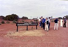
Cameron Corner Survey Marker
[5] In 1863 surveyors Francis Edward Roberts from Queensland and Isaiah Rowland from New South Wales were chosen to survey the boundary line from Point Danger west to the Dumaresq River.
At the direction of the Queensland Surveyor-General, Roberts deviated from the definable position of the watershed in order to increase the accuracy of the survey.
[7] Augustus Charles Gregory, Queensland Surveyor-General and William Albert Baylesford Greaves, NSW District Surveyor of the Northern Rivers, conducted this initial survey of latitude 29S.
In July 1862 Sir Charles Nicholson[9] had reported to the Secretary of State for the Colonies that: "On the west, the whole of the basin of the 'Barcoo' for several hundred miles, as far as the 142nd meridian of East longitude, is becoming rapidly occupied by squatters, and the authorised possession of the greater part of it has already, I believe, been secured under pastoral licenses...".
This land, comprising the floodplains of the Mulligan, Georgina, Diamantina and Bulloo Rivers and Cooper Creek, which form part of a vast inland drainage system originating in Queensland's central west and north-west and eventually reaching Lake Eyre, became known as Channel Country.
At first, the flow of goods into Queensland through the inland routes was not sufficient in either quantity or value to warrant the cost of collecting customs duty in remote areas.
A small Customs Border Patrol consisting of a police inspector, sub-inspector and four constables was appointed with powers to collect duties from 1 January 1871.
It was soon reported that the effect of increased vigilance on the border was to concentrate the importation of goods at Brisbane, reducing the amount of such trade through inland centres.
[1][16] Finally in June 1879 the surveying of the remainder of the Queensland-NSW border along the 29th parallel of south latitude extending into the Channel Country was undertaken.
[17] Having determined the position for the border and the longitude of a point on it and the direction of the true meridian found, surveyors John Brewer Cameron from NSW and George Chale Watson (Commissioner for Crown Lands for the Warrego and Gregory South) representing Queensland, started to survey westerly on 15 September 1879 from a point on the east bank of the Warrego River where they had erected the Zero Obelisk.
In March 1880 after reaching the 100-mile post on the Paroo River, Surveyor Watson withdrew from the survey party, having written "As I believe Mr Cameron capable of working within great precision and he is evidently a painstaking officer over his professional duties, I have no reason to doubt but that the work would be precise enough for all the purposes of scientific accuracy as Mr Cameron, added to his other qualifications, has a supreme regard for his own reputation".
[22] According to Bill Kitson, Watson had other reasons for withdrawing – he resented having to continue his duties as land commissioner while working on the border survey as it meant he was unable to fully participate and made him "the laughing stock of the NSW contingent".
[24] Cameron identified the corner between Queensland, NSW and South Australia with a timber post marked with the government arrow and LAT 29.
By 1879 he was a First Class Surveyor in the Trigonometrical Branch of the NSW Lands Department and a member of the Royal Geographical Society of New South Wales.
In 1883 he moved to New Guinea, acquired a plantation and later guided the Government Resident, Sir William MacGregor, on journeys of exploration.
[28] Afterwards, his former colleague in marking the NSW-Queensland border, George Watson, stated "and so passed away an energetic spirit worthy of classification as a man of genius.
Current technology such as the Global Positioning System (or GPS) enables places to be pinpointed by longitude and latitude more accurately.
This variation in the intention and reality of the border corner shows the continued difficulties of surveying remote regions.
[1] Nearby are:[1] Cameron Corner Survey Marker was listed on the Queensland Heritage Register on 9 November 2012 having satisfied the following criteria.
Set borders were an important part of colonial economic and administrative development, providing certainty for governments and pastoralists, and enabling the collection of customs duties.
[1] Cameron Corner is the result of early cooperation between Australian colonies and provides lasting evidence of the feat of endurance necessary to complete the Queensland-New South Wales border survey.