Canterbury and Whitstable Railway
Until the early 19th century, Canterbury's line of supply for goods had been along the River Stour which flows to Pegwell Bay, near Ramsgate on the eastern coast of Kent.
Whitstable, on the coast about seven miles (11 km) due north, was at that time a small fishing village and port with a trade in iron pyrites from the Isle of Sheppey.
The idea for the line came from William James who surveyed the route and produced plans for improving the harbour.
The immediate problem was that the land between Whitstable and Canterbury rose to a height of two hundred feet (61 m) and railway haulage on steep gradients was technically very difficult at that time.
The only alternative would have been a much longer route through Sturry, Herne and Swalecliffe and land acquisition would have been a major cost.
Accordingly, the direct route was chosen, with three steep gradients, two of them to be worked by ropes from stationary steam engines at Clowes Wood and Tyler Hill.
[5] From Canterbury North Lane station, the line climbed for 1 mile 70 chains (3.02 km) at 1 in 46 to Tyler's Hill, where there were two 25 horsepower (19 kW) winding engines.
[citation needed] The gradient eased to 1 in 750 for a further 1 mile 10 chains (1.81 km) to the summit of the line at Clowes Wood, where there was a 15 horsepower (11 kW) winding engine.
[6] The line finally opened on 3 May 1830,[3] with a single track throughout and passing loops at Clowes Wood and the entrance to Tyler Hill tunnel.
[citation needed] The track consisted of 28 pounds per yard (14 kg/m) fifteen-foot (4.6 m) fish-bellied iron rails,[7] laid on wooden sleepers at three-foot (0.91 m) intervals, the more usual alternative of stone blocks being considered too expensive.
However, the promoters insisted on use of a locomotive for the least difficult incline, and Invicta was procured from Robert Stephenson and Company, and it was brought to Whitstable by sea.
[9] Invicta was later given to the Canterbury City Corporation, and for many years stood on a plinth in the Dane John Gardens beside the Riding Gate.
When the South Eastern Railway's own network eventually reached Canterbury in 1846,[15] it decided to convert the line for use with its own locomotives throughout,[16] after upgrading the track using standard rails of 70 pounds per yard (35 kg/m).
[14] In 1902, work started on building a spur line at Whitstable to connect with the Herne Bay to Faversham line and a bay platform at Whitstable Town station, but the work was stopped when the Board of Trade demanded major improvements to the C&W before they would approve the new connection.
[23] It continued to carry coal, grain and roadstone, with munitions to the harbour during World War II.
By 1948, when it became part of British Railways, Whitstable Harbour had fallen into disuse and what was left of the line's trade had disappeared.
All traces of the Whitstable Harbour stations have been removed and the sites are occupied by public toilets and a medical centre, respectively.
The concrete base of the former goods shed that stood between the mid-1920s and 2009 is still visible adjacent to the harbour, with the former entrance gates still displaying the initials "SE&CR" (South Eastern & Chatham Railway).
There is no trace of South Street Halt, although remains of the level crossing gates were visible until the early 1980s.
The railway embankment can be clearly seen from the adjacent cycle route bridge as it crosses fields and is cut through by the A299 road.
A plan was mooted in the 1980s to open a railway museum on the site, but it remained derelict until being sold for housing development and the extension of Station Road West in about 1998.
The original weighbridge house and a level crossing gate into the former goods yard are preserved in the development.
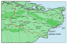
In 1999, a 7 mile long footpath and cycleway was opened between Canterbury and Whitstable, running along part of the original trackbed.