Cape York Peninsula
Although much of the peninsula remains pristine, with a diverse repertoire of endemic flora and fauna, some of its wildlife may be threatened by industry and overgrazing as well as introduced species and weeds.
In 1606, Dutch sailor Willem Janszoon on board the Duyfken was the first European to land in Australia, reaching the Cape York Peninsula.
In February 1606, Dutch navigator Willem Janszoon landed near the site of what is now Weipa, on the western shore of Cape York Peninsula.
The aim was to establish a route to the tip of the peninsula, where Sydney businessmen were attempting development of a port for trade with the East Indies.
There is no clear demarcation to the south, although the official boundary in the Cape York Peninsula Heritage Act 2007 of Queensland runs along at about 16°S latitude.
[8] At the peninsula's widest point, it is 430 km (270 mi) from the Bloomfield River in the southeast, across to the west coast just south of the aboriginal community of Kowanyama.
Almost all this rain falls between November and April, and only on the eastern slopes of the Iron Range is the median rainfall between June and September above 5 mm (0.2 in).
To the west, a series of large, winding river systems including the Mitchell, Staaten, Coleman, Holroyd, Archer, Watson, Wenlock, Ducie and Jardine catchments empty their waters into the Gulf of Carpentaria.
Tapping those heavy tropical rainfalls, the peninsula's rivers are also of particular importance for replenishing central Australia's Great Artesian Basin.
As it collided with the Pacific Plate on its northward journey, the high mountain ranges of central New Guinea emerged around 5 million years ago.
During periods of glaciation and resulting low sea levels, Cape York Peninsula provided a low-lying land link.
About 30 km (19 mi) offshore north of the tip of Cape York, there is a sizeable service centre on nearby Thursday Island.
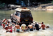
The road north of Lakeland Downs to the tip of the peninsula is sometimes cut after heavy rains during the wet season (roughly December to May).
The traditional language area for Luthigh includes landscape within the local government boundaries of the Cook Shire: Eastern Cape York, Ducie River, Northern Peninsula, New Mapoon, Injinoo, and Cowal Creek.
[21] Thaynakwith (also known as Awngthim, Tainikuit and Winduwinda) is an Australian Aboriginal language spoken on Western Cape York in the Weipa area taking in Albatross Bay and Mission River.
[22] Uradhi (also known as Anggamudi, Ankamuti, Atampaya, Bawtjathi, and Lotiga) is an Australian Aboriginal language of the Western Cape York Peninsula.
Following the displacement of Indigenous people by British settlement, it was also spoken in the Northern Peninsula Area Region including the communities of New Mapoon, Injinoo and Cowal Creek.
The traditional language area of Kuuku Ya'u includes landscape within the local government boundaries of the Cook Shire: Eastern Cape York, Uu'ungun south to Claudie River and hinterland.
[25] Kuuk Thaayorre (also known as Koko-Daiyuri, Kuku Yak, Thayorre, and used as a generic name for several related languages/dialects) is an Australian Aboriginal Language spoken on Western Cape York Peninsula, particularly in the area around Pormpuraaw (Edward River).
[31] On 25 November 2021, 2,188 km2 (845 sq mi) of land on the eastern side of the peninsula were handed back to the Kuuku Ya'u and Uutaalnganu peoples, in a native title claim that was lodged seven years prior.
[2] The savannah woodlands consist typically of a tall dense grass layer and varying densities of trees, predominantly eucalypt of which the most common is Darwin stringybark (Eucalyptus tetrodonta).
[7] These various habitats are home to about 3300 species of flowering plants[36] and almost the entire area of Cape York Peninsula (99.6%) still retains its native vegetation and is little fragmented.
[40] Rainforests depend on some level of rainfall throughout the long dry season, climatic conditions that are mostly found on the eastern slopes of the peninsula's coastal ranges.
As a result, from its geological history, "the flora and fauna of Cape York Peninsula are a complex mixture of Gondwanan relics, Australian isolationists and Asian or New Guinean invaders" (p. 41).
[41][42] The rainforests of the Kutini-Payamu National Park support species that are also found in New Guinea, including the eclectus parrot and southern common cuscus.
The riverbanks of the lowlands are home to specific wildlife of their own while the rivers including the Jardine, Jackson, Olive, Holroyd and the Wenlock are rich in fish.
[43][44] Much has been damaged by overgrazing, mining, poorly controlled fires and feral pigs, cane toads, weeds, and other introduced species[45][46] but Cape York Peninsula remains fairly unspoilt with intact and healthy river systems and no recorded plant or animal extinction since European settlement.
The tele track was used for construction and maintenance of the OTL until it was superseded by first microwave relay towers and then by fibre optic cables, and is now used by four-wheel drive vehicle enthusiasts in the dry season.
In 1992, investor support failed, and in 2017, legal ownership of 160,000 ha (400,000 acres) of land required was returned to the Wuthathi, Kuku Yau and Northern Kaanju people.
[49][50] The development, which was heavily supported by Queensland premier Joh Bjelke-Petersen, would have included a new town, tourist resorts, an airport and a harbour.